6.7 km away
Bernese Oberland Tour: Finsteraarhorn Hut to the Konkordia Hut via Trugberg
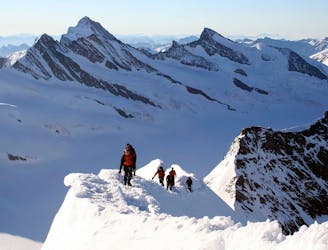
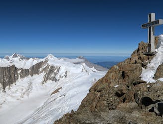
Day 4: Over the Grunhornlucke, a short descent then ascent of Trugberg, 3880m
Difficult Ski Touring
- Distance
- 18 km
- Ascent
- 1.7 km
- Descent
- 1.8 km
First Ski descent of Schreckhorn 4078m by Vivian Bruchez and Aurélien Lardy Ski all the 4000 m summits of the Alps! Is it really possible? The Schreckhorn was one of them, my 77th summit on this trip to the peaks. Creation of a new ski itinerary on June 12, 13 and 14, 2024, access to the mountain by train and return by Packraft (inflatable kayak) via the Rhône. For the past 4 springs, I've been devoting all my energy to the #4000desalpesaski project, sometimes traversing normal routes, other times exploring new itineraries. The Schreckhorn was high on my list of priorities, because it's not easy to get to and, along with its close neighbor the Lauterraahorn, is considered to be one of the wildest in the Alps. Located in the Bernese Oberland, their popularity lies in the shadow of giants such as the Eiger, Jungfrau and Mönch, clearly visible from Grindelwald! The king of the sector could be the Finsterraahorn, towering above the glaciers! Through this project, I want to bear witness to the beauty of the Alps and the wealth of activities practised there and their evolution. Getting to Grindelwald by train from Chamonix is really easy, although, let's be honest, it's a financial cost. But it offers a real sense of travel. What's more, every station has lockers where you can leave your equipment. Very useful when you're mixing different activities. The glaciers of the Oberland feed the Rhône, and the choice to enter Packraft was a natural one. It begs the question: where does the mountain begin and end? All the same, it requires a bit of training and a navigation permit from the canton of Valais. Finding the right rope-mates for this kind of adventure was easy with our friend Aurel Lardy, whose adventure in Alaska last year with stalwarts Hellias Millerioux , Alexandre Marchesseau and Christophe Tricou was a great success. Where they spent 50 days self-sufficiently traversing glaciers, peaks and rivers. I don't know if in 3 days, close to home, he's rediscovered the feeling of the wilderness, but in my opinion we're getting close, with one difference: accessibility. It's often a question of state of mind. Thomas Guerrin completed the roped party with the mission of bringing back images, so he didn't ski the whole line, but played a major part in the success of the adventure. We skied the North and South sides of the mountain, closely following the route of the first ascent in 1864. The top of the line is steep, narrow and airy, while the bottom is wide and welcoming. We took the Packraft from Sion to Martigny, returning home by train. I'm delighted to have brought to fruition a project that had been on my mind for months, if not years. It just goes to show that, to succeed in an adventure, you have to prepare well!
Ski Touring Extreme

Ski all the 4000 m summits of the Alps! Is it really possible? The Schreckhorn was one of them, my 77th summit on this trip to the peaks. Creation of a new ski itinerary on June 12, 13 and 14, 2024, access to the mountain by train and return by Packraft (inflatable kayak) via the Rhône. For the past 4 springs, I've been devoting all my energy to the #4000desalpesaski project, sometimes traversing normal routes, other times exploring new itineraries. The Schreckhorn was high on my list of priorities, because it's not easy to get to and, along with its close neighbor the Lauterraahorn, is considered to be one of the wildest in the Alps. Located in the Bernese Oberland, their popularity lies in the shadow of giants such as the Eiger, Jungfrau and Mönch, clearly visible from Grindelwald! The king of the sector could be the Finsterraahorn, towering above the glaciers! Through this project, I want to bear witness to the beauty of the Alps and the wealth of activities practised there and their evolution. Getting to Grindelwald by train from Chamonix is really easy, although, let's be honest, it's a financial cost. But it offers a real sense of travel. What's more, every station has lockers where you can leave your equipment. Very useful when you're mixing different activities. The glaciers of the Oberland feed the Rhône, and the choice to enter Packraft was a natural one. It begs the question: where does the mountain begin and end? All the same, it requires a bit of training and a navigation permit from the canton of Valais. Finding the right rope-mates for this kind of adventure was easy with our friend Aurel Lardy, whose adventure in Alaska last year with stalwarts Hellias Millerioux , Alexandre Marchesseau and Christophe Tricou was a great success. Where they spent 50 days self-sufficiently traversing glaciers, peaks and rivers. I don't know if in 3 days, close to home, he's rediscovered the feeling of the wilderness, but in my opinion we're getting close, with one difference: accessibility. It's often a question of state of mind. Thomas Guerrin completed the roped party with the mission of bringing back images, so he didn't ski the whole line, but played a major part in the success of the adventure. We skied the North and South sides of the mountain, closely following the route of the first ascent in 1864. The top of the line is steep, narrow and airy, while the bottom is wide and welcoming. We took the Packraft from Sion to Martigny, returning home by train. I'm delighted to have brought to fruition a project that had been on my mind for months, if not years. It just goes to show that, to succeed in an adventure, you have to prepare well!


Extreme
Extreme skiing terrain above 45 degrees. These routes are reserved for experienced experts.

In case of a fall, the skier faces certain death.
In the high mountains or remote conditions, all individuals must be completely autonomous in every situation.
6.7 km away
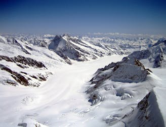
Day 4: Over the Grunhornlucke, a short descent then ascent of Trugberg, 3880m
Difficult Ski Touring
6.7 km away
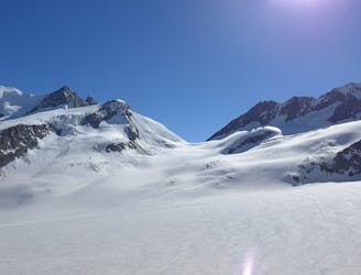
Day 2: Two summits of 4000m that can easily be combined in a single outing.
Difficult Ski Touring
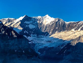
6.7 km away
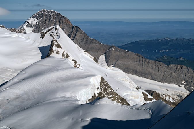
Day 3: A high summit, returning to the same hut. The Gross Wannenhorn, 3906m.
Difficult Ski Touring
6.8 km away
Day 4: This is a long distance journey to relocate to beneath the Aletschhorn. NOTE THE OLD BIVI HUT HERE WAS COMPLETELY DESTROYED BY AVALANCHE JAN '19 SO THERE IS NO HUT ANY MORE
Moderate Ski Touring
6.8 km away
Day 3: The largest summit in the Bernese Oberland and the 15th highest major 4000m peak in the Alps.
Difficult Ski Touring
9.4 km away
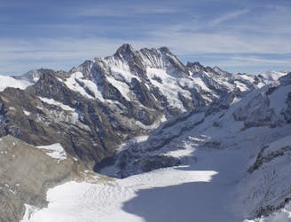
Day 1: A positioning day from the top of the Jungfraujoch train, easily down the glacier then a 500m skin over a pass at 3820m.
Moderate Ski Touring
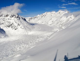
9.4 km away
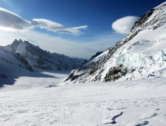
Day 1: The amazing Jungfraujoch railway accessing the biggest glaciated area in Europe and our first ski peak on the way to the hut.
Difficult Ski Touring
9.5 km away
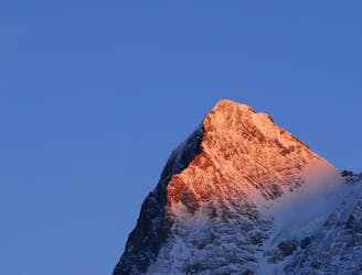
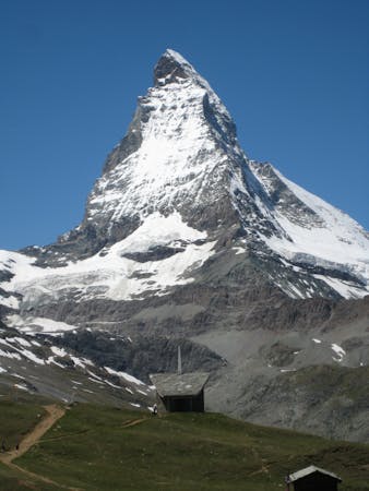
One of the most sought after ski lines in the Alps on a truly legendary mountain.
Extreme Ski Touring
9.7 km away
Day 5: Traverse of Kranzberg, 3666m, followed by ascent to the Hollandia Hut, 3235m
Severe Ski Touring
9.7 km away
Day 2: Over a pass, descending the far side before reascent to the Wysnollen, 3590m
Moderate Ski Touring
5 routes · Ski Touring

16 routes · Ski Touring
3 routes · Ski Touring