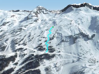
377 m away
Tete du geant traverse

A long hike access line until the summit where a really steep hike is present including a steep line.
Extreme Freeride Skiing
- Distance
- 536 m
- Ascent
- 0 m
- Descent
- 257 m
One of the biggest line of resort into a really high freeride area in autonomous line.
Freeride Skiing Extreme

Take the "Cornebois" chairlift we will be taking red slope "La Perdrix Blanche" following the hiking part of "Happy valleys bis line", at the highest part of the line we will hike up 50 meters higher to the peak in front of us. Our line will start with 50 degrees of steepness, going into some section without much steepness, finishing into some trees. Face is taking a lot of sun so remember before getting there, mistake will be not welcome you will be alone and avalanche risks are often high in this part of the mountain. As soon as the see the trees area ski through the trees to cross a little river, hike up will be needed into a little forest getting you back to blue slope "31 - La Tovassière", bringing you back to Morgins side.
Extreme
Extreme skiing terrain above 45 degrees. These routes are reserved for experienced experts.

In case of a fall, death is highly likely.

In the high mountains or remote conditions, all individuals must be completely autonomous in every situation.
377 m away
A long hike access line until the summit where a really steep hike is present including a steep line.
Extreme Freeride Skiing
457 m away

A famous part of the ski resort for off piste skiing, including a few optional cliffs.
Difficult Freeride Skiing
462 m away

A famous part of the ski resort for off piste skiing
Difficult Freeride Skiing
701 m away

Gentle line feeling like a slope.
Moderate Freeride Skiing
935 m away

Technical line ending up on really steep terrain.
Extreme Freeride Skiing
943 m away
A nice line starting easy but requiring good skills later on.
Severe Freeride Skiing
953 m away

Gentle line, getting much steeper in the middle section.
Severe Freeride Skiing
954 m away

A long line with a gentle first part and some steepness into the middle part.
Extreme Freeride Skiing
957 m away

A really nice traverse line that is good in bad visibility and often untracked.
Difficult Freeride Skiing
991 m away

Another nice shortcut in an easy part of the mountain giving some nice tree skiing.
Moderate Freeride Skiing