12 m away
Happy valleys line

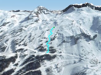
A famous part of the ski resort for off piste skiing, including a few optional cliffs.
Difficult Freeride Skiing
- Distance
- 921 m
- Ascent
- 0 m
- Descent
- 211 m
A famous part of the ski resort for off piste skiing
Freeride Skiing Difficult

Our line goes past the famous happy valleys off piste area. Even if a lot of people go there we are still off piste and our line will be well beyond this area. We are close to the "Tete du Linga" mountain where a few gullies can bring avalanches down . From the top of the "Cornebois" chairlift we will need to take into the red slope "La Perdrix Blanche" in order to keep some speed to get into our traverse under the ridge section. This will take us about 20 minutes walking until we will arrive in the higher section where our line starts. An optional cliff can be taken at the beginning of our run of about 7-10 meters, then we will continue to the right to get to the bottom of the flat area under the "Tete du Linga". We are aiming to keep as much speed than possible to pass the middle section instead of going down the little gully into the left. Next hike up to a flat area- this will take about 10-15 minutes, then you will get back to a nice area with trees. This gives you access back to the blue slope "L’itinéraire" where you will be able to join the bottom of the "Cornebois" chairlift and "Les combes".
Difficult
Serious gradient of 30-38 degrees where a real risk of slipping exists.

As well as the slope itself, there are some obstacles (such as rock outcrops) which could aggravate injury.

Little chance of being seen or helped in case of an accident.
12 m away
A famous part of the ski resort for off piste skiing, including a few optional cliffs.
Difficult Freeride Skiing
329 m away

Gentle line feeling like a slope.
Moderate Freeride Skiing
462 m away

One of the biggest line of resort into a really high freeride area in autonomous line.
Extreme Freeride Skiing
485 m away

Technical line ending up on really steep terrain.
Extreme Freeride Skiing
500 m away

Gentle line, getting much steeper in the middle section.
Severe Freeride Skiing
501 m away

A long line with a gentle first part and some steepness into the middle part.
Extreme Freeride Skiing
617 m away

A long traverse line close to the red slope "Les Rennes" where the main hazard is avalanches from the Chésery mountain.
Severe Freeride Skiing
735 m away
A nice line starting easy but requiring good skills later on.
Severe Freeride Skiing
802 m away

A long hike access line until the summit where a really steep hike is present including a steep line.
Extreme Freeride Skiing
869 m away

Another nice shortcut in an easy part of the mountain giving some nice tree skiing.
Moderate Freeride Skiing