1.9 km away
Twin Buttes Loop

Enjoy a 360-degree red rock sensory experience on this incredible hike!
Difficult Hiking
- Distance
- 6.1 km
- Ascent
- 155 m
- Descent
- 155 m
Hike to a beautiful and wildly-popular overlook.
Hiking Difficult

Chicken Point is a popular Sedona destination for Jeepers and hikers alike. You're also likely to see trail runners, mountain bikers, and maybe even unicyclers enjoying the spectacular views from these elevated rock ledges.
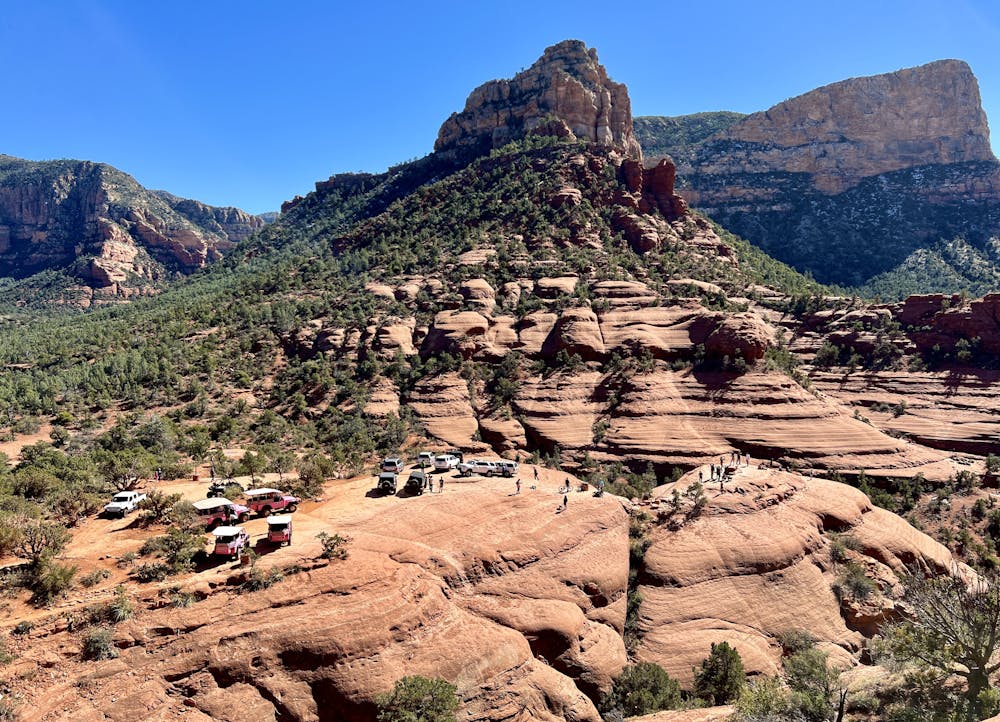

One of the best ways to hike to Chicken Point is via the Broken Arrow Trail. This route to Chicken Point offers spectacular views the entire way, as you'll be hemmed in on all sides by towering red rock formations! The pass itself sits between the formidable East Twin Butte and Gibraltar Rock. This trail also offers the option of taking a detour to Submarine Rock, one of the most famous rock formations in Sedona.
The route mapped here depicts a 2.8-mile out-and-back hike from the Broken Arrow trailhead to Chicken Point and back. While the elevation gain is fairly moderate at less than 400 vertical feet, the trail to reach the point is quite rocky and ledge-filled, as one might expect from a Sedona hiking trail.
Despite the rocks, ledges, and uncertain footing in places, most hikers will have no problem reaching the point. In fact, one of the biggest challenges might be managing trail traffic—from hordes of hikers, to trail runners moving at high speeds, and quite likely a number of mountain bikers, you'll need to hike heads-up and be prepared to be courteous and share the trail.
Thankfully, the Broken Arrow trailhead is one of the less-popular trailheads in the Sedona area, meaning that parking shouldn't be quite as challenging as it is in some other areas. However, especially on weekends and during peak season, plan to arrive at the trailhead early to beat the crowds.
Difficult
Hiking trails where obstacles such as rocks or roots are prevalent. Some obstacles can require care to step over or around. At times, the trail can be worn and eroded. The grade of the trail is generally quite steep, and can often lead to strenuous hiking.

The trail contains some obstacles such as outcroppings and rock which could cause injury.
Away from help but easily accessed.
1.9 km away
Enjoy a 360-degree red rock sensory experience on this incredible hike!
Difficult Hiking
2.4 km away

Gorgeous loop around Airport Butte offering spectacular views of the valley.
Moderate Hiking
2.5 km away

A hike that follows an exciting expert-level mountain bike route.
Severe Hiking
5 km away

A fantastic 5-mile loop around Brin's Butte.
Difficult Hiking
5 km away

Hike and scramble to one of the most beautiful caves in Sedona.
Severe Hiking
6.6 km away
Short hike to a stunning overlook.
Difficult Hiking
8.9 km away

Hike to arguably Sedona's most famous tourist site.
Moderate Hiking
9 km away
A view-heavy hike to the highest point in the Sedona area
Difficult Hiking
14 routes · Hiking

10 routes · Alpine Climbing · Canyoning · Hiking