4.1 km away
Cookie Drop

Large boulder/cliff drop area
Difficult Freeride Skiing
- Distance
- 1.2 km
- Ascent
- 1 m
- Descent
- 364 m
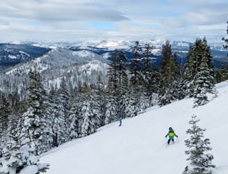
A Moderate Chute on Bald Mountain that takes quite a lengthy hike to get to
Freeride Skiing Moderate

As you drive into Northstar Ski Resort, you'll see a perfectly cut run off Bald Mountain in the distance. Turn right instead of left at one of the round-a-bouts heading to Northstar and follow the path on the map until you reach the trailhead of the Perimeter Trail located right below the summit of Bald Mountain. This path (like some of the Bushwhacking paths) winds up the front face of Bald Mountain (meaning, you'll get a great view of your run). If you want, you can even walk to the foot of the Chute itself and hike up to the summit (though this is not advisable as it might ruin the snow quality). If you stick with the Perimeter trail, it'll continue to wind up Bald Mountain until you crest over its shoulder. At this point instead of bushwhacking straight up to the summit from the shoulder, make the smart decision to walk a bit further down the Perimeter trail. Eventually, make a quick Bushwhack to join the Bald Mountain Motorcycle trail and join with the main trail on the backside of the mountain. This trail is actually a perfectly cut trail and goes straight up Bald Mountain's backside, hence why it's advisable to traverse over to it. Eventually after you continue straight up this trail you'll get to the summit of Bald Mountain and to the top of the Bald Mountain Chute.
The chute itself usually holds snow very well, however, since it's at an extremely low elevation, it'll need quite a bit for it to be worth skiing. In terms of difficulty and length, this is comparable to some of the runs off East Ridge at Northstar (Powder Bowl, Crosscut, Tonini's, The Chute. Dutchman, Delight, etc...), yet it's a lot more enjoyable than those due to it not being nearly as trafficked. It's definitely worth a try on a powder day!
Moderate
Slopes become slightly steeper at around 25-30 degrees.

Exposure is limited to that of the slope itself. Getting hurt is still likely if the slope is steep and/or the snow is hard.

Little chance of being seen or helped in case of an accident.
4.1 km away
Large boulder/cliff drop area
Difficult Freeride Skiing
4.1 km away

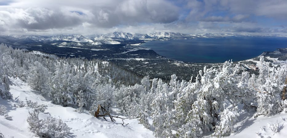
Great Views of Lake Tahoe Basin on the Mountain
Difficult Freeride Skiing
4.1 km away

A perfect spot for powder photoshoots
Severe Freeride Skiing
4.1 km away

Great views of Lake Tahoe and large boulders to drop off of.
Difficult Freeride Skiing
5.4 km away

Drop after drop after drop
Difficult Freeride Skiing
5.8 km away

A large Cornice atop Sawtooth Ridge
Severe Freeride Skiing
5.9 km away

A popular locals spot on Sawtooth Ridge
Severe Freeride Skiing
6.4 km away
The best hike-to terrain at Northstar when conditions permit
Difficult Freeride Skiing
8 routes · Freeride Skiing