1.3 km away
Phantom Bridge Trees
A large section of steep woods between Phantom Bridge and Railbender trails
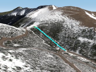
Difficult Freeride Skiing
- Distance
- 490 m
- Ascent
- 0 m
- Descent
- 150 m
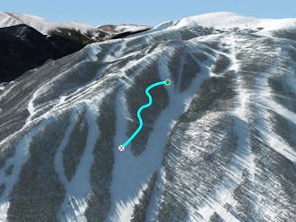
Awesome tree section with some opportunities for air
Freeride Skiing Difficult

This is a popular freeride skiing route which is generally considered to be difficult. It's remote, it features low exposure (e1) and is typically done between November and May. From a low point of 3.1 km to the maximum altitude of 3.2 km, the route covers 340 m, 0 vertical metres of ascent and 165 vertical metres of descent.
This tree section is a fantastic way to get to Mary Jane on a powder day. Starts out steep and pretty open but gets flatter and very tight at the bottom. Exiting out to frenchman before it gets too tight is popular.
Difficult
Serious gradient of 30-38 degrees where a real risk of slipping exists.

Exposure is limited to that of the slope itself. Getting hurt is still likely if the slope is steep and/or the snow is hard.

Away from help but easily accessed.
1.3 km away
A large section of steep woods between Phantom Bridge and Railbender trails
Difficult Freeride Skiing
1.9 km away

A steep tightly gladed area with small cliffs and unexpected obstacles
Severe Freeride Skiing
2.8 km away

A steep forest of trees that take you out of bounds from Parry's Peak on Parsenn Bowl to Highway 40
Difficult Freeride Skiing
2.9 km away

A slanted but fun trail directly under Panoramic Lift
Moderate Freeride Skiing
7.9 km away

Some south facing glades
Difficult Freeride Skiing
7.9 km away

Mellow tree skiing.
Moderate Freeride Skiing
8.2 km away

No-hike-necessary tree skiing on Hell's Half Acre.
Moderate Freeride Skiing
8.3 km away

No-hike-necessary tree skiing thanks to a shuttle on Berthoud Pass.
Moderate Freeride Skiing
8.4 km away
A low-angle cut through the trees
Moderate Freeride Skiing
15 routes · Freeride Skiing · Ski Touring

77 routes · Freeride Skiing · Ski Touring