2 km away
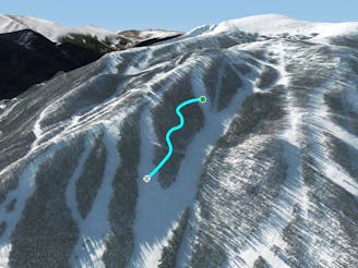
Pano Lift Line

A slanted but fun trail directly under Panoramic Lift
Moderate Freeride Skiing
- Distance
- 1.7 km
- Ascent
- 0 m
- Descent
- 378 m
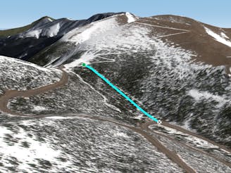
assess to the terrain past G chute
Freeride Skiing Extreme

This is the continuation of cirque assess past G chute after passing through the gate the next drop is shadow chute about a half mile later. Then after that is jellyroll feeding into jelly roll glade beyond that is backcountry and unpatrolled. This area is not open often and can go years without opening your best bet is late march on a good snow year.
Extreme
Extreme skiing terrain above 45 degrees. These routes are reserved for experienced experts.

Exposure is limited to that of the slope itself. Getting hurt is still likely if the slope is steep and/or the snow is hard.

Little chance of being seen or helped in case of an accident.
2 km away
A slanted but fun trail directly under Panoramic Lift
Moderate Freeride Skiing
3.3 km away

A steep forest of trees that take you out of bounds from Parry's Peak on Parsenn Bowl to Highway 40
Difficult Freeride Skiing
3.4 km away

A steep tightly gladed area with small cliffs and unexpected obstacles
Severe Freeride Skiing
3.6 km away
A large section of steep woods between Phantom Bridge and Railbender trails
Difficult Freeride Skiing
5.4 km away

Some south facing glades
Difficult Freeride Skiing
5.6 km away

Mellow tree skiing.
Moderate Freeride Skiing
6 km away

No-hike-necessary tree skiing on Hell's Half Acre.
Moderate Freeride Skiing
6.1 km away

No-hike-necessary tree skiing thanks to a shuttle on Berthoud Pass.
Moderate Freeride Skiing
6.2 km away
A low-angle cut through the trees
Moderate Freeride Skiing
15 routes · Freeride Skiing · Ski Touring

77 routes · Freeride Skiing · Ski Touring