7.4 km away
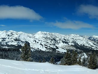
Elevator / Milly Gut Bootpack

A tough hike with glorious views at the top.
Moderate Freeride Skiing
- Distance
- 366 m
- Ascent
- 182 m
- Descent
- 0 m
A steep shot in the trees next to The Reef.
Freeride Skiing Difficult

This is a popular freeride skiing route which is generally considered to be difficult. It's not remote, it features medium exposure (e2) and is typically done between December and March. From a low point of 2.7 km to the maximum altitude of 2.9 km, the route covers 519 m, 0 vertical metres of ascent and 216 vertical metres of descent.
A steep shot in the trees next to Charlie Brown and The Reef. It is regularly open and spits you out at the End Zone.
Difficult
Serious gradient of 30-38 degrees where a real risk of slipping exists.

As well as the slope itself, there are some obstacles (such as rock outcrops) which could aggravate injury.

Close to help in case of emergency.
7.4 km away
A tough hike with glorious views at the top.
Moderate Freeride Skiing
7.5 km away

Cliff area just past the ski area boundary on Milly Bowl
Severe Freeride Skiing
7.6 km away

A fun run through open aspen glades
Difficult Freeride Skiing
7.6 km away

An exciting area with a variety of cliff and chute options
Difficult Freeride Skiing
7.7 km away

A steep, semi tree-d run on the west side of Mount Millicent
Severe Freeride Skiing
7.7 km away

A steep, rocky chute running down the middle of Mount Millicent. For experts only.
Severe Freeride Skiing
7.8 km away

Steep, rocky run, through tight trees that finishes in tight little chutes
Severe Freeride Skiing
7.9 km away

A steep run through trees with several different chute options.
Difficult Freeride Skiing
8 km away

A partly open, partly tree-d run just outside the resort boundary
Difficult Freeride Skiing
8 km away
A classic longer line for skiers willing to make the walk
Difficult Freeride Skiing