3.2 km away
Scotty's Bowl

Scotty's is a classic north facing roadside attraction in upper Little Cottonwood Canyon.
Difficult Ski Touring
- Distance
- 1.8 km
- Ascent
- 23 m
- Descent
- 754 m
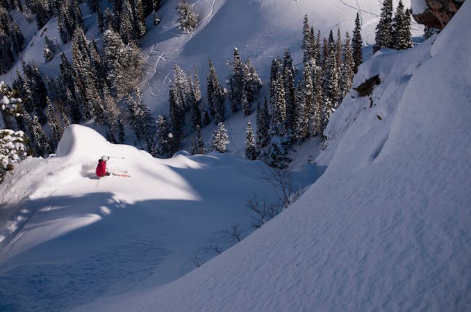
The diving board is a very steep and exposed run that keeps the mind from wandering while you're high in the central Wasatch.
Ski Touring Extreme

It's best to hike up this line so you can check the snow conditions and really there isn't a better way. Park at the S curve 4.3 miles up Big Cottonwood Canyon. Hike up the Mill B trail to Lake Blanche. From the lakes head up the E branch of the upper canyon. Keep going into the uppermost cirque and you'll see the Diving Board to the lookers left of Rampage.
The top of the line isn't that steep, but it slowly rolls over and steepens just as you hit the crux where you cut back skiers right and onto the angling ramp. The crux can be in the upper 50's and a fall here would be fatal so make sure the snow is good, or downclimb if it's not. The ramp flattens out quite a bit, but there is still huge exposure and the snow usually has some fun wavy wind features.
Extreme
Extreme skiing terrain above 45 degrees. These routes are reserved for experienced experts.

In case of a fall, the skier faces certain death.
In the high mountains or remote conditions, all individuals must be completely autonomous in every situation.
3.2 km away
Scotty's is a classic north facing roadside attraction in upper Little Cottonwood Canyon.
Difficult Ski Touring
3.8 km away

Old Growth chute is a mini classic that provides great rock wall lined ambience and easy access.
Difficult Ski Touring
3.9 km away

Virginia Slims is the fun dogleg chute next to the more popular Old Growth chute in the lower reaches of Cardiff Fork.
Difficult Ski Touring
3.9 km away

A big fun run off of Kessler Peak with some great chute and trees skiing involved.
Difficult Ski Touring
4.3 km away

This is the huge avalanche path that's visible from the road on the N slope of Kessler Peak.
Difficult Ski Touring
4.6 km away

Stairs Gulch is 4,000 feet long, serious with a combination of a steep, technical chute and a flat, more mellow finish.
Difficult Ski Touring
5.6 km away

Probably the longest, most consistent rock-lined chute in the Wasatch if you're into that sort of thing.
Severe Ski Touring
7 km away

The Dresden is one of the longest and most continually steep faces in the Wasatch.
Severe Ski Touring
7.9 km away

Access from Brighton to backcountry zones like Patsy Marley and Wolverine Cirque.
Moderate Ski Touring
9.3 km away

Major Tom is a steep and sporty couloir in a remote corner of the Wasatch that can have a few rappels to navigate!
Extreme Ski Touring

18 routes · Resort Ski Touring · Ski Touring
9 routes · Resort Ski Touring · Ski Touring