253 m away
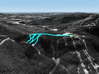
Sally's Alley

A short but steep face that terminates into tight trees.
Severe Freeride Skiing
- Distance
- 114 m
- Ascent
- 0 m
- Descent
- 62 m
Gnarliest In-Bounds run at Smuggs
Freeride Skiing Severe

This is a popular freeride skiing route which is generally considered to be severe. It's very remote, it features high exposure (e3) and is typically done between January and April. From a low point of 924 m to the maximum altitude of 1.1 km, the route covers 216 m, 0 vertical metres of ascent and 128 vertical metres of descent.
This was off limits for several seasons due to a difficult extraction of someone, So ski at your own risk. There may be a rope blocking the top, depending on the day and the season.
Severe
Steep skiing at 38-45 degrees. This requires very good technique and the risk of falling has serious consequences.

In case of a fall, death is highly likely.
Little chance of being seen or helped in case of an accident.
253 m away
A short but steep face that terminates into tight trees.
Severe Freeride Skiing
266 m away

A tight evergreen glade for expert skiers.
Moderate Freeride Skiing
365 m away

One of the hardest unmarked glades on the mountain.
Severe Freeride Skiing
706 m away

Short little stash off Lower Chilcoot.
Moderate Freeride Skiing
1.1 km away

The inbounds continuation of Hershey Highway.
Moderate Freeride Skiing
1.3 km away

A tight glade skiers right of Smugglers Alley.
Moderate Freeride Skiing
1.4 km away

A handful of turns through unmarked woods.
Moderate Freeride Skiing
1.6 km away
A short hike/sidestep some wide side country glades.
Difficult Freeride Skiing
2 km away

A massive backcountry glade with a number of drop ins
Difficult Freeride Skiing
2.4 km away

A low angle trail used to cross from Spruce Peak to Sterling Peak and to access the Back Bowls.
Easy Freeride Skiing