4.4 km away
Mount Hunger via Waterbury Trail
Straight up the slope of Mount Hunger to its panoramic summit.
Difficult Hiking
- Distance
- 5.6 km
- Ascent
- 696 m
- Descent
- 696 m
The trail to the top of Mount Hunger from the east side.
Hiking Severe

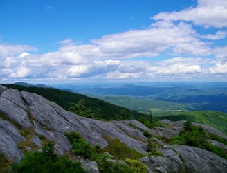
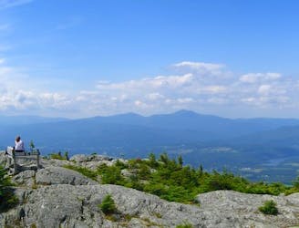
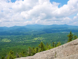
This trail begins near the towns of Worcester and Middlesex, and is the way to reach the top of Mount Hunger from its east side. Hunger is not the tallest in its range, but it’s arguably the most scenic, with a broad, bare-rock summit that affords huge views in all directions.
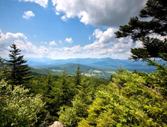
Middlesex Trail is a straightforward hike by Vermont mountain standards. It follows blue blazes on an obvious path through dense forest, with the usual assortment of rocks, roots, and mud along the way. At one point you’ll pass a signed junction with White Rock Trail, an alternative route to the summit that crosses over a neighboring peak on the way. Stay on Middlesex Trail for the more direct route up Mount Hunger.
Near the top is a particularly steep section, where you’ll use a fixed rope to ascend a slab, and possibly use your hands in few other places. The gradient lessens just before the end, and on top you’ll find a spacious summit and ridgeline. From there, on a clear day, the view is quite expansive. You can see the Green Mountains to the west, including the iconic peaks of Mount Mansfield and Camels Hump. Far to the east you can see the White Mountains of New Hampshire. This summit is also one end of the Skyline Trail, which continues on a rugged traverse of the range.
Sources: https://fpr.vermont.gov/putnam-cc-state-forest https://www.summitpost.org/mount-hunger/213410
Severe
Hiking challenging trails where simple scrambling, with the occasional use of the hands, is a distinct possibility. The trails are often filled with all manner of obstacles both small and large, and the hills are very steep. Obstacles and challenges are often unexpected and can be unpredictable.

The trail contains some obstacles such as outcroppings and rock which could cause injury.
Away from help but easily accessed.
4.4 km away
Straight up the slope of Mount Hunger to its panoramic summit.
Difficult Hiking
4.4 km away
A committing traverse of the surprisingly rugged and varied peaks east of Stowe.
Severe Hiking
7.3 km away
Shorter route to the top of Stowe Pinnacle.
Difficult Hiking
7.7 km away

Rewarding hike to a lesser-known summit of the mountains near Stowe.
Difficult Hiking
7.7 km away
A must-do hike in Stowe, to a granite dome with 360-degree views of the valley and surrounding mountains.
Difficult Hiking
8 routes · Hiking
10 routes · Hiking