51 m away
Elizabeth Lake (Run)

An open glade that offers a long run to Elizabeth Lake and an easy return to a groomed run.
Difficult Freeride Skiing
- Distance
- 310 m
- Ascent
- 0 m
- Descent
- 132 m
A steep open glade that shelters deep snow days after a storm
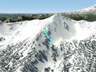
Freeride Skiing Difficult

A steep, north-facing run that shelters deep snow days after a storm, this open glade runs a consistent grade and fall line from Lizard's Back Ridge to Elizabeth Lake. The top of this run is divided by a steep tree island. Wiggle your way through the trees on either side. Note that the skier's left side of the run is a little steeper and eventually ends in thick trees, forcing you to work right. The right hand line offers a top to bottom line but is often tracked out first. Prevailing winds deposit snow here. Watch out for avalanches, ski one at a time and keep an eye on your partner. Access via the first Southback gate, traversing to Kirner's Cornice and hiking up the boot pack to the summit of the King. Work your way down Lizard's Back ridge, avoiding trees and rocks.
Difficult
Serious gradient of 30-38 degrees where a real risk of slipping exists.

Exposure is limited to that of the slope itself. Getting hurt is still likely if the slope is steep and/or the snow is hard.

Away from help but easily accessed.
51 m away
An open glade that offers a long run to Elizabeth Lake and an easy return to a groomed run.
Difficult Freeride Skiing
64 m away

The entrance to this short, narrow chute is guarded by a leaning tree.
Severe Freeride Skiing
87 m away

A short and steep glade for experts
Difficult Freeride Skiing
99 m away

A short steep glade for experts
Difficult Freeride Skiing
144 m away
Link this gladed face with Damn Fine Forest for a consistent run of approximately 800 vertical feet.
Difficult Freeride Skiing
216 m away

A hidden, steep glade with fairly easy access.
Difficult Freeride Skiing
223 m away

This shallow couloir is a great first Double Black Diamond for those looking to challenge themselves on the north side of the King.
Difficult Freeride Skiing
273 m away

A narrow, steep couloir on the north side of the King.
Severe Freeride Skiing
293 m away

An often-untracked steep glade in Silver Basin.
Severe Freeride Skiing
330 m away

An open face along the SE side of Silver King ("The King") that leads into glades, chutes and cliffs.
Difficult Freeride Skiing