46 m away
SE King Left

An open face along the SE side of Silver King ("The King") that leads into glades, chutes and cliffs.
Difficult Freeride Skiing
- Distance
- 347 m
- Ascent
- 0 m
- Descent
- 204 m
An often-untracked steep glade in Silver Basin.
Freeride Skiing Severe

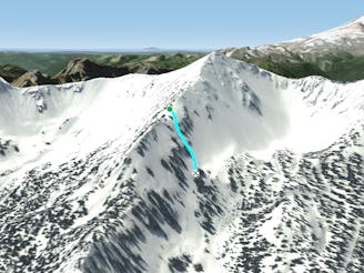
SE King Left #2 is an often-untracked steep glade in Silver Basin. The name is used only by the ski patrol in avalanche control, and rarely referred to as such. Most people prefer not to refer to it, and simply keep it a secret as the short face at the bottom of this slope often holds powder snow days after a storm. The trick with this run is finding it. New trees have obscured the entrance from the top. Access from the left side of SE King Left, wiggle your way through the trees, avoid the more obvious entrance to Divider Chute and continue traversing left until you reach a steep, open glade. A tree island divides the lower face. Milk the edges of the trees for the deepest snow. The far skier's left side of the steep glade often holds snow the longest. At the bottom, work your way right towards the Judges Knoll for the easiest way back to the ski area. Otherwise, follow the gradient through the mature timber, avoiding flat spots (especially if you're a snowboarder) and watch out for deep tree wells, eventually reaching a groomed outrun. Follow back to Quicksilver run.
Severe
Steep skiing at 38-45 degrees. This requires very good technique and the risk of falling has serious consequences.

As well as the slope itself, there are some obstacles (such as rock outcrops) which could aggravate injury.
Away from help but easily accessed.
46 m away
An open face along the SE side of Silver King ("The King") that leads into glades, chutes and cliffs.
Difficult Freeride Skiing
78 m away

A narrow, steep couloir on the north side of the King.
Severe Freeride Skiing
95 m away

This shallow couloir is a great first Double Black Diamond for those looking to challenge themselves on the north side of the King.
Difficult Freeride Skiing
101 m away

This popular, wide-open chute is one of the easiest couloirs on the north side of the King.
Difficult Freeride Skiing
157 m away
Link this gladed face with Damn Fine Forest for a consistent run of approximately 800 vertical feet.
Difficult Freeride Skiing
165 m away

This is one of the best lines in Silver Basin, starting in an open face, funneling through a wide and shallow couloir and opening again to the lower basin.
Difficult Freeride Skiing
167 m away

This iconic and challenging couloir is for experts only.
Severe Freeride Skiing
168 m away

A steep, rocky face reserved for experienced experts
Extreme Freeride Skiing
180 m away

A steep, rocky face for experienced experts
Extreme Freeride Skiing
195 m away

A short steep glade for experts
Difficult Freeride Skiing
13 routes · Freeride Skiing · Ski Touring
14 routes · Freeride Skiing · Ski Touring