Jefferson, Adams, and Madison Via Great Gulf

Summiting three 5000 footers and a T25
Extreme Hiking
- Distance
- 22 km
- Ascent
- 1.8 km
- Descent
- 1.8 km

Go hiking in New Hampshire with curated guides of the best hikes across the region. With over 212 3D trail maps in FATMAP, you can easily discover and navigate the best trails in New Hampshire.
No matter what your next adventure has in store, you can find a guide on FATMAP to help you plan your next epic trip.
Get a top hiking trail recommendation in New Hampshire from one of our 6 guidebooks, or get inspired by the 212 local adventures uploaded by the FATMAP community. Start exploring now!
Summiting three 5000 footers and a T25
Extreme Hiking

Hike up one of the presidentials
Difficult Hiking

Up Boott Spur, down Lions head
Severe Hiking

More challenging way up and down Monadnock
Difficult Hiking

Easy hike up Monadnock
Moderate Hiking

Relatively flat hike up Mount Passaconway
Easy Hiking
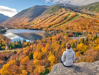
The perfect leaf peeping hike in Franconia Notch.
Moderate Hiking

Loop up the tripyramids
Difficult Hiking

Up Huntington down Lion's Head
Severe Hiking

A 1 night backpacking trip along the Franconia Ridge, tenting at Liberty Springs Campsite
Difficult Hiking

Hut, Wildcat A, Carter Dome, Mt. Hight
Difficult Hiking

Traverse of the Moriah Carter and Wildcat Peaks.
Severe Hiking

White Mountains National Park
Difficult Hiking

White Mountains National Park
Difficult Hiking

White Mountains National Park
Difficult Hiking

White Mountains National Park
Moderate Hiking