17 m away
Gaislachkogl avalanche barrier left

Long big mountain off-piste. Because of the danger in the beginning of the line it is for experienced riders only.
Difficult Freeride Skiing
- Distance
- 1.5 km
- Ascent
- 0 m
- Descent
- 658 m
A steep and narrow big mountain couloir on top of Gaislachkogl. For experts only!
Freeride Skiing Severe
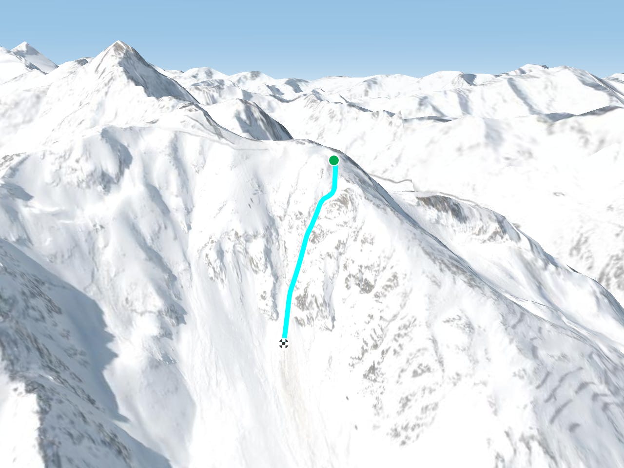
This line is for experts. It's a steep and narrow couloir top to bottom, until the mountain gets mellower and the face opens up. The difficulty of this line is finding the entry because at the beginning you need to find the right couloir. On this part of the mountains there are a lot of lines, but this one is a special one. It is totally straight after a little curve to the left in the beginning. To go for this line, make your way to the top of Gaislachkogl. Like many other lines, you'll need to follow slope number 1 before entering. Get to the 180 degree lefthand bend with the Gaislachkogl on the left side and exit the piste on the outside of the bend. For orientation: on the left side there will be wooden fences. On the outside of the left curve, there will be a yellow sign to inform you about the big mountain danger in this area, and that you are leaving the safe slopes. Behind this sign is the massive rocky ridge. Instead of going down here, follow the ridge for a few metres. The ridge will turn to the right approximately 100 metres after passing the yellow sign. Continue following for approx. 20 metres and then the entry comes. Get into the couloir and follow it. After the small curve on your left, you should see the whole line. A perfect straight line couloir. Of course, make sure to check it from the gondola first, the snow conditions need to be good. Also check if it is totally tracked, because if so it will not be that much fun. Ride it out and enjoy the rush of adrenaline, before coming down the mellow Wasserkar bowl under the gondola until you reach the pistes.
Severe
Steep skiing at 38-45 degrees. This requires very good technique and the risk of falling has serious consequences.

In case of a fall, death is highly likely.

Away from help but easily accessed.
17 m away
Long big mountain off-piste. Because of the danger in the beginning of the line it is for experienced riders only.
Difficult Freeride Skiing
95 m away

Big mountain off-piste on the infamous Gaislachkogl. Because of the danger in the beginning of the line this is reserved for experienced riders.
Difficult Freeride Skiing
210 m away

Non crowded big mountain off-piste for experienced skiers.
Severe Freeride Skiing
404 m away

Classic off piste with many variations down from Gaislachkogl for good riders
Severe Freeride Skiing
423 m away

Mellow big mountain off-piste for intermediates
Difficult Freeride Skiing
465 m away

Marvellous big mountain off-piste for intermediate skiers, away from the chairs and the crowds.
Severe Freeride Skiing
488 m away

Advanced off piste from the infamous Gaislachkogl.
Severe Freeride Skiing
496 m away

A beautiful big mountain line from Gaislachkogel, well away from the slopes.
Difficult Freeride Skiing
754 m away

Classic off piste down to Rettenbachtal for advanced riders
Difficult Freeride Skiing
1.1 km away

Off piste under Gratlift
Moderate Freeride Skiing
16 routes · Freeride Skiing