18 m away
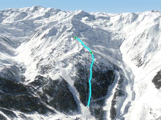
Pfaffen East run

Bumpy classic ride with a long descent, often crowded
Difficult Freeride Skiing
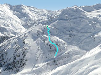
- Distance
- 1.9 km
- Ascent
- 0 m
- Descent
- 497 m
Secret tree run, ideal line on bad days.
Freeride Skiing Moderate

This a secret spot on good and bad days in Hochfügen! It's empty on beautiful sunny days and there is always some nice snow, even when there are windy and foggy conditions. You can easily spend a whole day here, because getting back to the starting point only requires a five minute lift on the Pfaffenbühel T-Bar. When you are coming from the valley, you just need to take the 8er jet and follow the slope number 10 until you reach the top station of the Pfaffenbühel T-Bar. The line itself takes a parallel line to the Pfaffenbühel T-Bar, to the skiers left.
On the west of the station there is a flat part, with a freeride checkpoint, which is really useful to check your safety equipment. There are also some resort maps. The easiest way is to drop into the slope behind the freeride checkpoint signs and stay on the right side of the slope, where some single trees are standing.You will notice the T-Bar appearing on the right, just a few metres beside you. Stay on this side until it's getting flatter after about 300 metres. Here you can stay on the right near the lift, because there is a open slope with less bushes than on the left side, but also more tracks. On the left there are a lot bushes, you can easily find your own new line here and some rocks and bushes to jump over. You will end up right in front of the Pfaffenbühel T-Bar, perfect for starting the next run. As described at the beginning, on a day with bad weather or avalanche safety conditions this is THE run in Hochfügen.
Moderate
Slopes become slightly steeper at around 25-30 degrees.

As well as the slope itself, there are some obstacles (such as rock outcrops) which could aggravate injury.

Close to help in case of emergency.
18 m away
Bumpy classic ride with a long descent, often crowded
Difficult Freeride Skiing
35 m away
Tree run for bad days
Difficult Freeride Skiing
36 m away

Wide slope in the woods, nice run for bad weather days.
Difficult Freeride Skiing
110 m away
Nice tree run with bumps, good on bad days
Difficult Freeride Skiing
516 m away

Short route with steep parts and cliffs underneath the 8er Jet gondola.
Difficult Freeride Skiing
789 m away

Nice route under the 8er Jet, OK in bad conditions
Moderate Freeride Skiing
913 m away

Short and steep section with trees and woods, fun in bad weather.
Difficult Freeride Skiing
1.6 km away
True Classic of the Region. Start in Hochfügen itself.
Difficult Freeride Skiing
1.6 km away

Beautiful route with a long descent and a breathtaking panorama
Difficult Freeride Skiing
1.6 km away

Beautiful easy route with a long descent and a breathtaking panorama
Difficult Freeride Skiing
6 routes · Freeride Skiing

10 routes · Freeride Skiing