49 m away
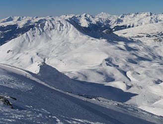
Carro Blanc

A long, interesting route away from the ski area
Difficult Freeride Skiing
- Distance
- 7.1 km
- Ascent
- 25 m
- Descent
- 1.1 km
Another long interesting itinerary into the deep valley separating Les Arcs from La Plagne
Freeride Skiing Difficult

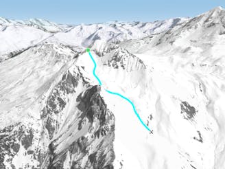
A fine companion route to the Carro Blanc, also starting from Le Chal, but a little steeper, and finishing higher up the valley. From behind the restaurant, head directly down gentle open slopes into the main bowl. As the stream bed start to become visible, stay above that on the right bank until the valley bottom flattens out. Cross the stream and now follow the left bank until you pass some small huts and come to the track heading right to Nancroix. Bear left here towards the edge of the main valley, and here traverse leftwards across a fairly steep slope, then pick a line through the trees to finish in the hamlet of Beaupraz.
Difficult
Serious gradient of 30-38 degrees where a real risk of slipping exists.

Little chance of being seen or helped in case of an accident.
49 m away
A long, interesting route away from the ski area
Difficult Freeride Skiing
82 m away

The easier way down the Aiguille Grive
Difficult Freeride Skiing
519 m away

A steep rarely skied line from the top of the Aiguille Grive
Severe Freeride Skiing
661 m away
A wild, steep line that needs stable snow conditions and finishes outside the lift served area
Severe Freeride Skiing
662 m away
A hike to some great views followed by a flowing descent down a west facing bowl
Moderate Freeride Skiing
1.1 km away

Short but sweet in bounds face
Moderate Freeride Skiing
2.5 km away

An incredible off-piste journey on the wild-side of the Aiguille Rouge
Difficult Freeride Skiing
2.6 km away

A mini-adventure with some steeper skiing at the start
Difficult Freeride Skiing
2.8 km away

Exposed Bowl on north west face
Severe Freeride Skiing
2.9 km away

a fairly exposed and often untracked line
Difficult Freeride Skiing
25 routes · Freeride Skiing