357 m away
Marmottes

Enjoyable, beautiful skiing but check the snow conditions before setting out
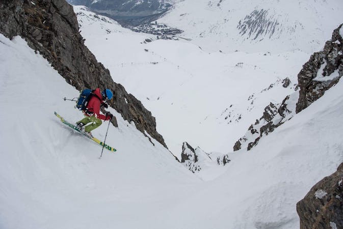
Severe Freeride Skiing
- Distance
- 1.9 km
- Ascent
- 0 m
- Descent
- 655 m
Good skiing with easy access, close to the pistes
Freeride Skiing Difficult

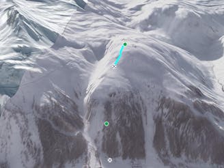
Never too far from the S piste the "Super S" provides great skiing in the right conditions. The relatively low altitude and West facing aspect can mean the snow doesn't stay good here for long and it can be avalanche prone. There are two variants. The skiers right which stays on the shoulder above the piste through a bunch of trees, or the skiers left which follows a short gully. If you take the skiers left hand line down the gully make sure you head back towards the piste as the end of the gully is steep with small rock bands. Both lines hit the point roughly where the red and black pistes merge.
Difficult
Serious gradient of 30-38 degrees where a real risk of slipping exists.

As well as the slope itself, there are some obstacles (such as rock outcrops) which could aggravate injury.
Away from help but easily accessed.
357 m away
Enjoyable, beautiful skiing but check the snow conditions before setting out
Severe Freeride Skiing
404 m away
This alternative line to the Lavancher couloir provides some steep tree skiing but can be dangerous.
Severe Freeride Skiing
543 m away

A popular, easy to access classic couloir - you'll need to get up early to get first tracks here.
Difficult Freeride Skiing
1.3 km away

Fun skiing on some great and varied slopes.
Severe Freeride Skiing
1.4 km away

Great short descent through open terrain and short forrest.
Difficult Freeride Skiing
1.6 km away

Wide open skiing with a few fun variations.
Difficult Freeride Skiing
2.3 km away

Great tree skiing - good for bad visibility/weather days
Difficult Freeride Skiing
2.5 km away

Short, steep, easy-access tree lines
Difficult Freeride Skiing
2.6 km away

A steeper alternative to the classic Banana line
Severe Freeride Skiing
2.7 km away

The classic, very popular Val d'Isere off-piste. Quickly tracked!
Difficult Freeride Skiing
70 routes · Freeride Skiing