3.5 km away
Tour du Mont Blanc: Day 4 Variant
A significant addition to the day but one which rewards your efforts
Difficult Hiking
- Distance
- 13 km
- Ascent
- 552 m
- Descent
- 1.3 km
Cross the Col de la Seigne back to France, descend through la Ville des Glaciers to Les Chapieux
Also in Aoste, Italy
Hiking Difficult

Today we are heading for the Val Veny and the start of our walk at La Visaille. We’ll reach this by bus to then start climbing gently along good paths beneath the massive glacier de Miage and pass Lac Combal before the gradient becomes steeper as we follow the old Roman road and head for today's pass: the Col de la Seigne (8,250ft/2,516m), which marks our re-entry into France. A fairly steep descent brings us through la Ville des Glaciers and finally after quite a long walking day to Les Chapieux, a remote hamlet inhabited only during the summer months.
Difficult
Hiking trails where obstacles such as rocks or roots are prevalent. Some obstacles can require care to step over or around. At times, the trail can be worn and eroded. The grade of the trail is generally quite steep, and can often lead to strenuous hiking.

The path is on completely flat land and potential injury is limited to falling over.

Away from help but easily accessed.
3.5 km away
A significant addition to the day but one which rewards your efforts
Difficult Hiking
4.9 km away
Day 5: Although this day is more of a detour than anything, it is a wonderful one in good weather. If the weather is bad or you're pushed for time, get the bus from Courmayeur to Arp Nouva to join stage 6 and skip out this stage.
Difficult Hiking
7.4 km away
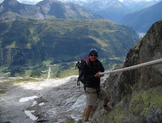
An exceptional, adventurous hike featuring some sections of easy via ferrata and exposed terrain.
Extreme Hiking

14 routes · Hiking

9 routes · Alpine Climbing · Hiking

10 routes · Alpine Climbing · Hiking