197 m away
Tour du Mont Blanc: Lavancher to La Fouly
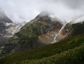
Day 6: The second border crossing and the highest col on the main Tour du Mont Blanc route.
Difficult Hiking
- Distance
- 18 km
- Ascent
- 871 m
- Descent
- 962 m
Climb to Bonatti refuge and traverse high above the spectacular Ferret Valley around Mont de la Saxe to Courmayeur
Hiking Moderate

We start with a short bus ride to pick up the TMB and from the road climb up to the Bonatti refuge (6,640ft/2,025m). Today we follow a beautiful contouring path around Mont de la Saxe to Courmayeur. The views of the south Mont Blanc massif are exceptional as are those of the towering peaks of the Grandes Jorasses and the glaciers which crowd the northern flank of the Val Ferret. In the afternoon we have a long, steep descent to Courmayeur from where we take a short bus ride into the spectacular Val Veny.
Moderate
Hiking along trails with some uneven terrain and small hills. Small rocks and roots may be present.

The path is on completely flat land and potential injury is limited to falling over.
Close to help in case of emergency.
197 m away
Day 6: The second border crossing and the highest col on the main Tour du Mont Blanc route.
Difficult Hiking
3.9 km away
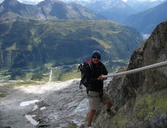
An exceptional, adventurous hike featuring some sections of easy via ferrata and exposed terrain.
Extreme Hiking
7.9 km away
Day 5: Although this day is more of a detour than anything, it is a wonderful one in good weather. If the weather is bad or you're pushed for time, get the bus from Courmayeur to Arp Nouva to join stage 6 and skip out this stage.
Difficult Hiking

14 routes · Hiking

9 routes · Alpine Climbing · Hiking

10 routes · Alpine Climbing · Hiking