140 m away
NW Seetali

Steep lines for experienced and extreme riders
Extreme Freeride Skiing
- Distance
- 944 m
- Ascent
- 0 m
- Descent
- 325 m
Take the tbar up under totalp and down backside of mountain
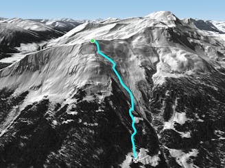
Freeride Skiing Difficult

This is a popular freeride skiing route which is generally considered to be difficult. It's remote, it features high exposure (e3) and is typically done between December and April. From a low point of 1.7 km to the maximum altitude of 2.5 km, the route covers 2.8 km, 58 vertical metres of ascent and 789 vertical metres of descent.
Quick hike up(15min) for a beatiful traverse and decent with nice snow and sick features on the way which takes you down to some tree skiing and then to the talabfahrt. Normally very nice snow as not many people go
Difficult
Serious gradient of 30-38 degrees where a real risk of slipping exists.

In case of a fall, death is highly likely.

Away from help but easily accessed.
140 m away
Steep lines for experienced and extreme riders
Extreme Freeride Skiing
315 m away

Great steep SE slope from the top of Parsennfurgga with easy access
Severe Freeride Skiing
336 m away

Wide freeride slope from Seetäli to Obersäas valley
Difficult Freeride Skiing
407 m away

Easy acces freeride area for intermediate riders
Moderate Freeride Skiing
578 m away

Freeride below Parsennfurgga (2443m) with easy acces
Moderate Freeride Skiing
1.8 km away

From Totalphorn (2532m) to Gruobenalp ski out (slope nº16)
Difficult Freeride Skiing
1.9 km away

Fun rocky slope on the Totalphorn north face
Severe Freeride Skiing
1.9 km away

Ridge riding for experienced skiers
Difficult Freeride Skiing
2.2 km away

Alpine rocky terrain for experienced riders
Severe Freeride Skiing
2.5 km away
Long freeride line from alpine to forest terrain for advanced skiers
Severe Freeride Skiing
18 routes · Freeride Skiing