246 m away
La Chaux - Le Chable via les Vacheresses

A long run down to Le Chable through the forest and villages, this route needs good snow cover.
Difficult Freeride Skiing
- Distance
- 3.8 km
- Ascent
- 7 m
- Descent
- 708 m
A long run down to Le Chable through the forest and villages but needs good snow cover.
Freeride Skiing Difficult

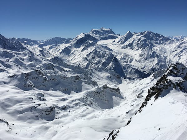
A long and enjoyable run down to Le Chable which needs good snow cover and is not often in condition - make sure you know you can get down or you are in for a very, very long walk. From La Chaux, ski directly south on the broad ridge. Continue down the open slopes towards Sarreyer, making sure never to head too far left. At 1520m either continue straight down to Sarreyer where you will need to arrange transport or turn right and follow the forest road and you pick up a forest road that continues all the way to Le Chable.
Difficult
Serious gradient of 30-38 degrees where a real risk of slipping exists.

Exposure is limited to that of the slope itself. Getting hurt is still likely if the slope is steep and/or the snow is hard.

Away from help but easily accessed.
246 m away
A long run down to Le Chable through the forest and villages, this route needs good snow cover.
Difficult Freeride Skiing
1.7 km away

Some steeper options from the classic James Blunt
Severe Freeride Skiing
1.8 km away

A classic bowl easily accessible from the Gentianes - La Chaux red piste.
Difficult Freeride Skiing
1.8 km away

A direct line down the south face of Mont Gele
Difficult Freeride Skiing
1.9 km away

The widest and least steep of the Attelas couloirs
Severe Freeride Skiing
1.9 km away

An enjoyable line down the west facing couloir from the top of Mont Gele
Difficult Freeride Skiing
1.9 km away

Another steep Mont-Gele classic couloir
Severe Freeride Skiing
2 km away

A marked itinerary towards the Cabane de Mont-Fort
Moderate Freeride Skiing
2 km away

Steep north facing couloirs from Mont Gele towards the Lac des Vaux
Difficult Freeride Skiing
2 km away

The main north facing couloirs from the top of Mont Gele
Severe Freeride Skiing
50 routes · Freeride Skiing
7 routes · Freeride Skiing · Ski Touring