.jpg?sfvrsn=124bfa04<em>0)
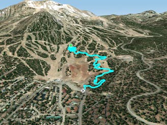
Uptown -> Downtown Loop

One of the easiest and most accessible trail rides in Mammoth Lakes.
Easy Mountain Biking
- Distance
- 15 km
- Ascent
- 301 m
- Descent
- 301 m
A fantastic pedal-driven loop beginning in downtown Mammoth Lakes.
Mountain Biking Moderate

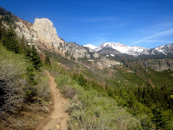
Paper Route is the main two-way singletrack trail traversing the flanks of Mammoth Mountain on the Juniper Springs Resort side. While some downhill riders use this trail to connect across the mountain, Paper Route is best-utilized for pedal-driven trail riding beginning in the heart of downtown Mammoth Lakes.
This flowy intermediate trail is smooth and mellow. While punctuated by roots and the occasional rock, Paper Route is definitely one of the easiest trails on the mountain. Overall, it rides like a classic backcountry singletrack, without much in the way of bike-optimized trail features.
While you can expect classic, loose Mammoth Mountain soil, some sections of the trail runs through deep pine groves with delicious sections of dark, loamy soil—a true treat in the Mammoth Lakes region!
This loop is formed by climbing up Uptown, climbing up Paper Route, and descending the downhill-only Juniper Trail. Juniper is still an intermediate trail, but it features many more flow-inducing features such as berms, rollers, and a bit steeper pitch than Paper Route.
Once back down to the valley floor, connect through town on beautiful bike paths to return to your starting point.
Note: when the bike park is running, a bike park pass is required to access these trails, even if you are pedaling up the mountain. Outside of the bike park season, you can pedal these trails for free if they’re snow-free.
Sources: https://www.youtube.com/watch?v=gMmAPJzqqaM https://d1pdyfnmzhu191.cloudfront.net/images/default-source/master/maps/2019bikeparktrailmapfront2000x1171-(2).jpg?sfvrsn=124bfa040 https://www.youtube.com/watch?v=EIPZpcFqg
Moderate
Mostly stable trail tread with some variability, with unavoidable obstacles 8in/20cm tall or less. Other obstacles such as rock gullies and steep sections may exist. Ideal for lower intermediate riders.

The path is on completely flat land and potential injury is limited to falling over.
Close to help in case of emergency.
One of the easiest and most accessible trail rides in Mammoth Lakes.
Easy Mountain Biking
1.4 km away

A flowy intermediate ride with amazing views.
Moderate Mountain Biking
2.5 km away
An intermediate two-way singletrack trail on Mammoth Mountain.
Moderate Mountain Biking
2.6 km away

A chunky black-diamond finish to many top-to-bottom runs.
Severe Mountain Biking
3.1 km away

Flow trail to the max!
Difficult Mountain Biking
3.1 km away

One of the best-developed jump lines on Mammoth Mountain.
Extreme Mountain Biking
3.1 km away

A hidden gem in the Mammoth Bike Park.
Severe Mountain Biking
3.3 km away

The main two-way singletrack trail traversing the flanks of Mammoth Mountain.
Moderate Mountain Biking
3.4 km away

A downhill-only intermediate trail anchoring Mammoth Mountain's easy side.
Moderate Mountain Biking
3.5 km away

Chunky black diamond tech trail.
Severe Mountain Biking
5 routes · Mountain Biking
34 routes · Mountain Biking
8 routes · Mountain Biking