
A steep climb reaches high, barren, and boggy moorland which must be crossed before an estate track leads down to the A832. From there, footpaths and minor roads lead over high moorland again, passing a few small lochs, and descending once more to A832 near the sea.
Difficult Hiking
- Distance
- 19 km
- Ascent
- 786 m
- Descent
- 884 m

Crossing the Great Wilderness, tracing rivers and lochs on mostly good tracks but some pathless travel, with abundant views from comfortable wild-camp spots.
Difficult Hiking
- Distance
- 28 km
- Ascent
- 742 m
- Descent
- 663 m

This exceptionally beautiful stage begins by climbing steeply through forestry to Coulin Pass, then gently down an open valley with Beinn Eighe in view ahead. Continuing through a rural setting along the River Coulin, the path becomes more difficult as it enters a felled forest and regenerating growth before emerging at Kinlochewe.
Difficult Hiking
- Distance
- 16 km
- Ascent
- 462 m
- Descent
- 501 m

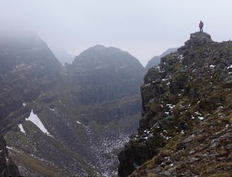
Continuing through very remote and rugged territory, this section occasionally follows vehicle tracks but otherwise rough trail, pathless sections, boggy ground, and water crossings.
Difficult Hiking
- Distance
- 24 km
- Ascent
- 674 m
- Descent
- 863 m
Standard Life Mountain Club
Extreme Hiking
- Distance
- 16 km
- Ascent
- 1.3 km
- Descent
- 1.3 km

24 munros, 24 hours, over two marathons with an elevation gain of 28500 feet/8686.8 metres
Extreme Hiking
- Distance
- 91 km
- Ascent
- 7.8 km
- Descent
- 7.8 km
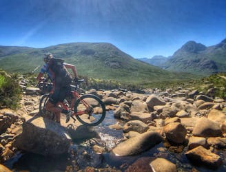
Cycle the classic Sligachan Pass. An exposed coastal hike leads to the longest rock climb in the UK. A multi day adventure.
Extreme Hiking
- Distance
- 20 km
- Ascent
- 1.1 km
- Descent
- 390 m

A short walk from Ptarmigan building to access some of the steepest freeride lines on the map
Easy Hiking
- Distance
- 2.5 km
- Ascent
- 217 m
- Descent
- 156 m
