Pinball Face

A steep, rocky face for experienced experts
Extreme Freeride Skiing
- Distance
- 72 m
- Ascent
- 0 m
- Descent
- 53 m
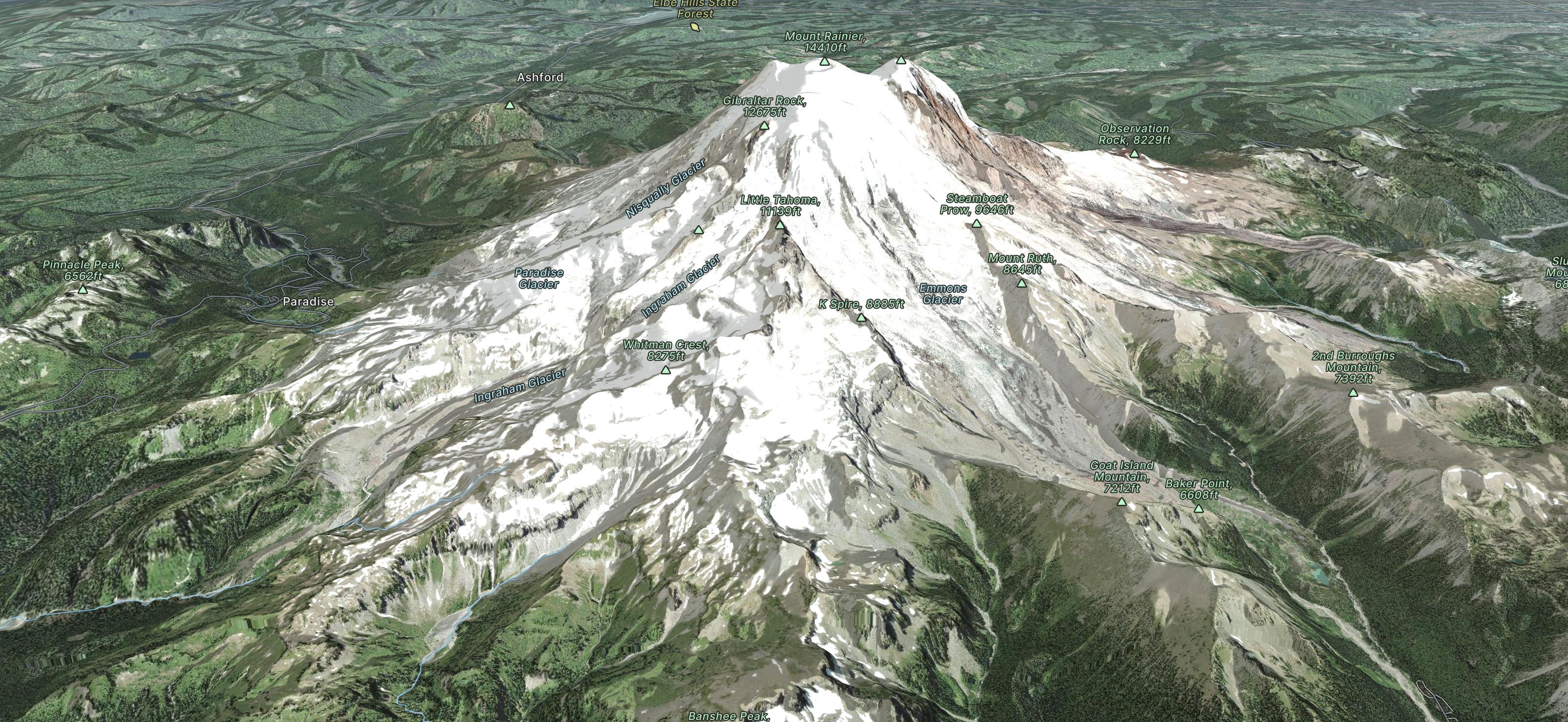
Go Freeride in Mount Rainier National Park with curated guides of the best routes across the region. With over 101 3D trail maps in FATMAP, you can easily discover and navigate the best routes in Mount Rainier National Park.
No matter what your next adventure has in store, you can find a guide on FATMAP to help you plan your next epic trip.
Get a top Freeride recommendation in Mount Rainier National Park from one of our 21 guidebooks, or get inspired by the 101 local adventures uploaded by the FATMAP community. Start exploring now!
A steep, rocky face for experienced experts
Extreme Freeride Skiing

A long hourglass couloir that opens into a wide bowl
Difficult Freeride Skiing

A wide chute tucked below Three Way Peak that holds fresh snow days after a storm.
Difficult Freeride Skiing

A narrow steep couloir boarded by rocky spines on both sides.
Severe Freeride Skiing

A wide chute split by a rocky buttress partway down.
Difficult Freeride Skiing

A steep, narrow couloir for experts only
Severe Freeride Skiing

Three short chutes guarded by a large cornice that open into an alpine bowl.
Difficult Freeride Skiing

A broad face that narrows into a steep chute before opening into Avalanche Basin.
Severe Freeride Skiing

A prominent rocky buttress offering numerous lines, mostly requiring mandatory air.
Severe Freeride Skiing

A shallow face that opens into a wider bowl
Difficult Freeride Skiing

A broad face with some trees and a variety of open lines
Difficult Freeride Skiing

A steep open glade.
Difficult Freeride Skiing

This 600 vertical foot run starts as an open face and narrows into steep gullies before opening into a wide basin
Severe Freeride Skiing

A challenging narrow chute above an open bowl
Extreme Freeride Skiing

A beautiful hourglass couloir above a wide bowl.
Severe Freeride Skiing

A steep couloir that narrows at its center
Severe Freeride Skiing