153 m away
East Valley
Providing more open and consistent fall line compared to the Southern Twin Valley, and some fantastic skiing
Difficult Freeride Skiing
- Distance
- 3.7 km
- Ascent
- 83 m
- Descent
- 470 m
Nice snow quality and steep pitches in the Southern Twin Valley
Freeride Skiing Moderate

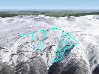
Most easily accessed from Thredbo from skinning North for about a kilometre from the top of Merritt's, then another 2 km North East and you will end up near the top of the Southern Twin Valley, from here the Southern Valley provides some nice snow quality lower down (away from the exposed wind scoured areas) and some nice pitches. It doesn't hold many of the consistent fall lines which the Northern Twin Valley does. The area flattens out around halfway depending on which line you take, as there are plenty, but the snow deteriorates following this flatter area, a base of around a metre at Spencer's Creek is a good indication for decent conditions lower down into the valley. Take care when the spring melt comes, there are plenty of streams underneath, and the vegetation is thick. Otherwise, in good fresh conditions, this area is simply awesome, visit the northern valley too! Hike/skin back up the way you came to return.
Moderate
Slopes become slightly steeper at around 25-30 degrees.

As well as the slope itself, there are some obstacles (such as rock outcrops) which could aggravate injury.

Little chance of being seen or helped in case of an accident.
153 m away
Providing more open and consistent fall line compared to the Southern Twin Valley, and some fantastic skiing
Difficult Freeride Skiing
1.8 km away

A local's favourite powder run when the resort is tracked out.
Difficult Freeride Skiing
4.1 km away

From Pulpit T Bar towards Carruthers
Moderate Freeride Skiing
4.2 km away

A local favourite, dropping 400 vertical metres not too far from Thredbo dropping down to Dead Horse Gap car park.
Moderate Freeride Skiing
4.7 km away

Involving a kilometre of fairly flat skiing to the south, the run then drops down the sheltered southern side of Kosciuszko.
Moderate Freeride Skiing
4.8 km away

The western flanks of Kosciuszko, the steepest skiing on the mountain other than the areas beneath the cornice
Moderate Freeride Skiing
4.8 km away

The mellow eastern face of Kosciuszko
Moderate Freeride Skiing
4.8 km away

The north eastern face of Australia's highest peak, Mt Kosciuszko, this lee slope is one of the earliest skiable slopes in Australia.
Moderate Freeride Skiing
5.1 km away

Steep and rocky, leading into a more open bowl down to Leatherbarrel Creek
Severe Freeride Skiing
5.5 km away

Starting on the summit of the Ramshead and heading the major drainage gully to the north, dropping down to Leatherbarrel Creek
Difficult Freeride Skiing

10 routes · Freeride Skiing
34 routes · Freeride Skiing · Ski Touring
4 routes · Freeride Skiing · Hiking · Ski Touring