2.2 km away
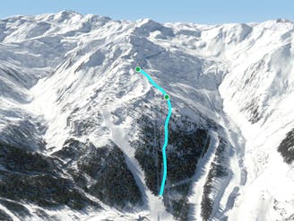
Marchkopf Northwest

Long descent with a big wide slope, easy to reach from the Zillertal Shuttle
Difficult Freeride Skiing
- Distance
- 5.3 km
- Ascent
- 356 m
- Descent
- 1.1 km
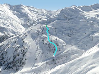
Secret spot on bad days here in Kaltenbach/Hochzillertal
Freeride Skiing Difficult

This short and steep tree run is a hot tip on days with bad weather and foggy conditions. It’s not very long, but sometimes the best route the resort offers. You need to go to the top with the Heißer 8er, in English Hot 8-man chairlift, which is very comfortable with the seat heating and a big bubble, perfect to warm yourself on freezing days. From the top you need to follow the red piste number 8, this one is quite flat at the beginning and it’s very easy to lose orientation on foggy days here. After 500m the slope immediately gets steep and turns into a black one. At this part there is the wood on the left side appearing. When the trees are about 5-10m from the piste you can ski into the woods. The first part is a little bit flat, but afterwards it gets steeper. Here you need to stay more on the right hand side, because on the left you may end up between small avalanche barriers. After 250m, the hill is turning more and more into a small and tight couloir. It depends on the snow conditions, you can go straight ahead here, when there are not many tracks, or you can cross to the right until a wide open slope appears. This hill is not that easy to find, so make sure you try to catch the line when you are doing the ascent with the chairlift if the visibility allows, as here you can see the line easily. The slope is about 200m long and it ends up on a small track, where you can ski back a short distance to the chairlift, to head for the next run. This route is a secret spot on bad days, also when it’s windy, because most of the time the snow gets drifted into the hills in between the trees.
Difficult
Serious gradient of 30-38 degrees where a real risk of slipping exists.

As well as the slope itself, there are some obstacles (such as rock outcrops) which could aggravate injury.

Close to help in case of emergency.
2.2 km away
Long descent with a big wide slope, easy to reach from the Zillertal Shuttle
Difficult Freeride Skiing
2.2 km away

Long descent through bushes and small trees, a good choice in poor conditions.
Difficult Freeride Skiing
2.9 km away

Nice route with good view from the chairlift nearby, also containing small cliffs.
Severe Freeride Skiing
5.5 km away

Wide slope in the woods, nice run for bad weather days.
Difficult Freeride Skiing
5.5 km away
Tree run for bad days
Difficult Freeride Skiing
5.6 km away

Bumpy classic ride with a long descent, often crowded
Difficult Freeride Skiing
5.6 km away

Secret tree run, ideal line on bad days.
Moderate Freeride Skiing
5.7 km away
Nice tree run with bumps, good on bad days
Difficult Freeride Skiing
6 km away

Short route with steep parts and cliffs underneath the 8er Jet gondola.
Difficult Freeride Skiing
6.2 km away

Nice route under the 8er Jet, OK in bad conditions
Moderate Freeride Skiing
6 routes · Freeride Skiing

10 routes · Freeride Skiing