669 m away
Marchkopf Tree Run

Long descent through bushes and small trees, a good choice in poor conditions.
Difficult Freeride Skiing
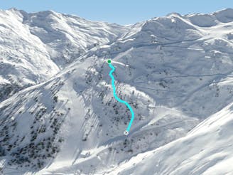
- Distance
- 4.4 km
- Ascent
- 282 m
- Descent
- 1 km
Nice route with good view from the chairlift nearby, also containing small cliffs.
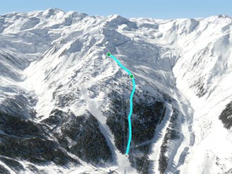
Freeride Skiing Severe

The Wedelride is a good route for one your first freeride lines here in the resort. From the Wedelexpress chairlift you can have a really good view of the face, to check your line before you enter. You need to get to the highest point of the resort, so when you come from Hochfügen you need to take the Zillertal Shuttle to the top or the Wedelexpress from Kaltenbach. At the top you need to hike 250 meters along the ridge at the right of the Wedelexpress to the northeast direction. You pass some avalanche barriers, then you need to go through the big gap before you pass the last barriers. You'll have a steep slope in front of you so try to keep a safe distance between you, because of the avalanche danger. The slope is pretty wide and you'll find enough space for your own line. After the 800m long descent you need to stay more on the right side to get back to the Wedelexpress. The route needs good visibility otherwise it is too dangerous.
Severe
Steep skiing at 38-45 degrees. This requires very good technique and the risk of falling has serious consequences.

As well as the slope itself, there are some obstacles (such as rock outcrops) which could aggravate injury.
Away from help but easily accessed.
669 m away
Long descent through bushes and small trees, a good choice in poor conditions.
Difficult Freeride Skiing
669 m away

Long descent with a big wide slope, easy to reach from the Zillertal Shuttle
Difficult Freeride Skiing
2.7 km away

Wide slope in the woods, nice run for bad weather days.
Difficult Freeride Skiing
2.7 km away
Tree run for bad days
Difficult Freeride Skiing
2.8 km away

Bumpy classic ride with a long descent, often crowded
Difficult Freeride Skiing
2.8 km away

Secret tree run, ideal line on bad days.
Moderate Freeride Skiing
2.9 km away

Secret spot on bad days here in Kaltenbach/Hochzillertal
Difficult Freeride Skiing
2.9 km away
Nice tree run with bumps, good on bad days
Difficult Freeride Skiing
3.2 km away

Short route with steep parts and cliffs underneath the 8er Jet gondola.
Difficult Freeride Skiing
3.5 km away

Nice route under the 8er Jet, OK in bad conditions
Moderate Freeride Skiing
6 routes · Freeride Skiing

10 routes · Freeride Skiing