2.3 km away
Mieders to Maria Waldrast
An ideal trip for families to a truly unique mountain restaurant.
Easy Hiking
- Distance
- 7.4 km
- Ascent
- 274 m
- Descent
- 274 m
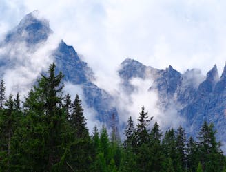
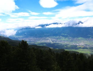
The so-called “Altar of Tirol”, Serles is the most famous peak in the region, and rules the view above Innsbruck.
Hiking Severe

Park up at the Maria Waldrast monastery (which, whilst still a monastery, is also an excellent mountain restaurant these days) then hike 500 metres south (initially on a road and then on a jeep track) to reach the lovely Ochsenalm hut, which is nestled at the edge of some rolling meadows beneath the imposing south-east face of Serles.
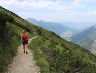
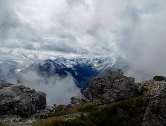
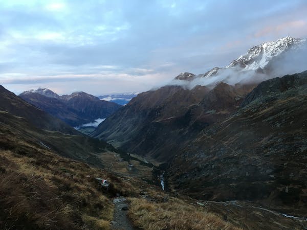
Hike south-west along the floor of the Matreier Grube valley, which is initially flat and then climbs increasingly steeply to reach the Kalbenjoch Col, a wide and wild space which feels far removed from civilisation and the bustle of the nearby villages. Head north off the col and make a spectacular traverse beneath the Lämpermahdspitze, heading for the Serlesjöchl Col. From the col there is an excellent view north down into the Stubai valley and across to the famous Kalkogel mountains and south to the nearby peak of Blaser.
From the col climb up the south-east ridge of Serles. The ridge features some scrambling and there are some sections of fixed cables which can be used both as a handrail and, at times, as handholds to pull on. Higher up the angle of the path eases off but the terrain underfoot is still somewhat precarious and takes you up some sections of scree. The ridge is perched high up on Serles (which towers over every other peak in the immediate vicinity) and feels very “out there” despite not being difficult or overly exposed.
Just below the summit is a rocky buttress which is easily negotiated but requires some very easy scrambling. Once through this, you are on the summit of one of Tirol’s greatest mountains - enjoy it! The view is all you would have hoped for so savour it and take plenty of photos.
Descend the ridge back to the Serlesjöchl Col and then drop steeply south-east and follow a good path as it loops around north-east to the Maria Waldrast. The last hour or so of the descent is through trees and can feel slightly tedious but the prospect of a cold beer and a great feed in the monastery should keep you going!
Severe
Hiking challenging trails where simple scrambling, with the occasional use of the hands, is a distinct possibility. The trails are often filled with all manner of obstacles both small and large, and the hills are very steep. Obstacles and challenges are often unexpected and can be unpredictable.

Some trail sections have exposed ledges or steep ascents/descents where falling could cause serious injury.
Little chance of being seen or helped in case of an accident.
2.3 km away
An ideal trip for families to a truly unique mountain restaurant.
Easy Hiking
4.5 km away

With its 2.169 m over sea level, the Pfoner Ochsenalm is one of the highest located serviced mountain huts of the Wipptal and offers a rustic place to enjoy the alpine flair.
Easy Hiking
5.1 km away

A must-do for all wildflower lovers as the Blaser is known as the most beautiful flower-mountain in Tirol.
Moderate Hiking
5.7 km away

One of the smaller hiking tours in Stubaital to the beautiful Kaserstattalm.
Difficult Hiking
6 km away
A long hiking loop over the Morgenkogel ridge with a stunning view
Severe Hiking
7.2 km away
A wonderful, mid-length, circular hike with impressive scenery through the dramatic peaks of the Stubai Valley.
Difficult Hiking
7.7 km away
A beautiful summit which is famous for being the first ever Alpine peak climbed by Sir Edmumd Hillary!
Difficult Hiking
9.6 km away
A stunning traverse high above the Inn valley, this is one of the most famous hikes in the Tirol.
Moderate Hiking

9 routes · Alpine Climbing · Hiking
9 routes · Alpine Climbing · Hiking
4 routes · Hiking

5 routes · Hiking

9 routes · Hiking

25 routes · Hiking
3 routes · Mountain Biking · Hiking
7 routes · Hiking