1.6 km away
Gamsroute

A great Zurs freeride run for experienced skiers and riders.
Difficult Freeride Skiing
- Distance
- 3.5 km
- Ascent
- 24 m
- Descent
- 923 m
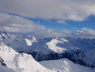
A nice moderate run with options of steep terrain and small trees. Possible in poorer visibility.
Freeride Skiing Moderate

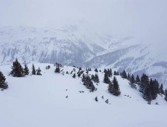
From top of Zursersee or Seekopf chairlifts turn left onto run 17 then onto run 18 and follow this run around the corner so facing east then from here one can leave the groomed run by turning sharply left. The first section is fairly open and a good chance to enjoy some large open turns in good powder. It then flattens out into a small meadow, either turn right and head for the small trees or continue straight across the meadow and sidestep or walk up to reveal large open terrain. The tree section can be tracked much quicker as it is possible in poorer visibility, however, there are many different lines available depending on ability. A small stream must be crossed but usually sufficient snow, then the final gentle slope down towards the tunnel. If taking the other option, after the walk up over the ridge, the first section appears steep, but soon the entire run will come into view and one can choose which route to take to lead onto the final gentle slope. This final section has large rocks, so take caution particularly when the snow pack is thin. Cross the Zursbach stream and skate alongside the tunnel to the bus stop.
Moderate
Slopes become slightly steeper at around 25-30 degrees.

As well as the slope itself, there are some obstacles (such as rock outcrops) which could aggravate injury.

Little chance of being seen or helped in case of an accident.
1.6 km away
A great Zurs freeride run for experienced skiers and riders.
Difficult Freeride Skiing
1.7 km away

A good run for dry powder in the Zurs front country.
Moderate Freeride Skiing
1.9 km away

A nice moderate open run down to Zurs-worth the traverse.
Moderate Freeride Skiing
2.1 km away

A superb wide open run with great views. A classic Zurs freeride.
Difficult Freeride Skiing
2.7 km away

Wide slopes and not too challeging in the Zurs front country.
Easy Freeride Skiing
3.8 km away
Freeride tour for skiers & split-boarders
Difficult Freeride Skiing
3.8 km away

Challenging terrain for the experienced on leeside slopes.
Severe Freeride Skiing
4.2 km away

Superb long run with often deep powder.
Difficult Freeride Skiing
4.4 km away
Fun Lech off piste runs for good and bad weather.
Moderate Freeride Skiing
6 km away

An enjoyable south facing run over St.Christoph.
Moderate Freeride Skiing
10 routes · Freeride Skiing