3.2 km away
Middle Needle Peak
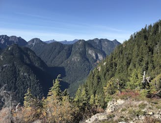
Follow a heavily forested ridge to one of Vancouver's lesser known peaks
Moderate Hiking
- Distance
- 20 km
- Ascent
- 1.5 km
- Descent
- 1.5 km
Hike Mount Fromme from St Georges
Hiking Difficult

Mount Fromme via St. George's and Peer Gynt Trails is a 9.7 kilometer moderately trafficked out and back trail located near North Vancouver District, British Columbia, Canada that features beautiful wild flowers and is rated as difficult. The trail is primarily used for hiking and is best used from May until September. Dogs are also able to use this trail.
Difficult
Hiking trails where obstacles such as rocks or roots are prevalent. Some obstacles can require care to step over or around. At times, the trail can be worn and eroded. The grade of the trail is generally quite steep, and can often lead to strenuous hiking.

The path is on completely flat land and potential injury is limited to falling over.
Close to help in case of emergency.
3.2 km away
Follow a heavily forested ridge to one of Vancouver's lesser known peaks
Moderate Hiking
7.4 km away

A beautiful oceanside pathway circumnavigating Stanley Park.
Easy Hiking
8.9 km away
A scrambly hike to the summit of Mt. Seymour
Difficult Hiking
9.6 km away
A moderate hike with excellent view over Vancouver and the Salish Sea
Moderate Hiking
9.6 km away
Challenging North Shore Hike
Difficult Hiking

6 routes · Hiking

3 routes · Hiking