218 m away
Leisch Canyon

Awesome scenery down a deep canyon between high cliffs.
Difficult Freeride Skiing
- Distance
- 1 km
- Ascent
- 1 m
- Descent
- 360 m
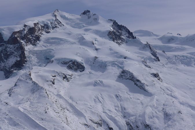
Enjoyable and steeper alternative to the Leisch canyon.
Freeride Skiing Difficult

This itinerary is a bit steeper than the Leisch canyon, but shorter. The entrance is not obvious due to high cliffs on all sides. It is possible to check the snow conditions from the middle of the gondola from Stafal to Gabiet by looking across to the left.
From the dam on the Endre plain, follow the itinerary that takes you back to the middle station at Gabiet. Just after a short uphill section, go down to a gentle slope on the right (west) until you reach the summit of a little hill. Ski down, first left then immediately right to pass some cliffs, and finally back to the left to reach the entrance of the couloir (exposed traverse). Ski down the couloir towards the wooded area and join the Leisch canyon itinerary to finish.
Difficult
Serious gradient of 30-38 degrees where a real risk of slipping exists.

In case of a fall, death is highly likely.
Little chance of being seen or helped in case of an accident.
218 m away
Awesome scenery down a deep canyon between high cliffs.
Difficult Freeride Skiing
685 m away

Tree skiing below the gondola.
Moderate Freeride Skiing
750 m away

A steep couloir close to the slope
Moderate Freeride Skiing
927 m away

A straightforward ski in some remote and captivating scenery.
Difficult Freeride Skiing
973 m away

Short add-on to the Moos couloir route with steep tree skiing.
Difficult Freeride Skiing
1.2 km away

A nice line in the woods, requires walking a bit
Moderate Freeride Skiing
1.4 km away

Ample slopes but needs a little walk at the beginning
Difficult Freeride Skiing
1.4 km away

Easy terrain to practice off-piste skills on a powder day.
Difficult Freeride Skiing
2.1 km away

One of the great classic routes in the Monte Rosa area: long and complex in high mountain terrain.
Moderate Freeride Skiing
2.3 km away

A nice slope and never too steep often in good powder!
Moderate Freeride Skiing
12 routes · Freeride Skiing