23 m away
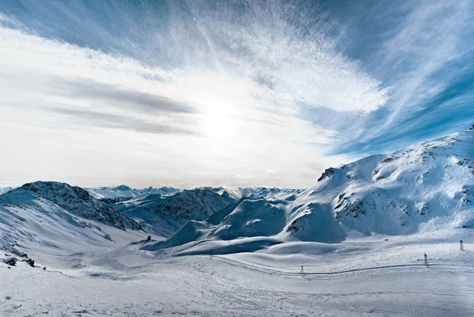
Pischa - Hüreli - Laret

Backcountry route for experienced riders
Difficult Freeride Skiing
- Distance
- 5.6 km
- Ascent
- 111 m
- Descent
- 1.1 km
Scenic route for advanced backcountry riders.
Freeride Skiing Difficult

From the top of Pischa we are gonna go to hike the SE ridge of Hüerli (2444m). It is a flat hike following the ridge covered aproximately between 20 or 40 minutes depending on the equipment used. Once at the peak we are gonna do another approach to the other peak in front of us, down the mountain pass and back up to the peak. Once at the spot the Davorser See should be visible down at the valley and Seehorn (2238m) just ahead on the left. Be aware that this route will finish on the east side of the lake so you can get easily oriented with that in order to follow the line down. We start going down leaving always Seehorn on the left. A clear wide area its visible down where the forest starts, it is a gentel wide slope the last section has some little cliffs and creeks with easy ways down, however the right side is the safest way down. This is the steeper section of the route. Down at the clear area there is a corridor in the forest on the lower left side, thats our final section down to Davoser See. Cross an off road trail and go down to the Lake trail. Once there just walk to the right to go to the bus station.
Difficult
Serious gradient of 30-38 degrees where a real risk of slipping exists.

As well as the slope itself, there are some obstacles (such as rock outcrops) which could aggravate injury.

In the high mountains or remote conditions, all individuals must be completely autonomous in every situation.
23 m away
Backcountry route for experienced riders
Difficult Freeride Skiing
6.2 km away

Techy pillow line through the forest
Difficult Freeride Skiing
6.2 km away

Popular off piste for intermediate riders
Severe Freeride Skiing
6.2 km away

Accessible easy off piste zone
Difficult Freeride Skiing
6.7 km away

Extreme freeride area for experienced riders
Severe Freeride Skiing
6.8 km away

Alpine Couloirs with easy access
Severe Freeride Skiing
6.8 km away

Rocky steep couloirs at Jakobshorn S face
Severe Freeride Skiing
7 km away

Backcountry route for experienced riders
Severe Freeride Skiing
7.1 km away

Gentle wide freeride with stunning views.
Moderate Freeride Skiing
7.2 km away

Popular off piste in the resort boundaries
Easy Freeride Skiing
14 routes · Freeride Skiing