80 m away
Rats Nest

A very steep and rocky way into Great Scott
Severe Freeride Skiing
- Distance
- 154 m
- Ascent
- 0 m
- Descent
- 88 m
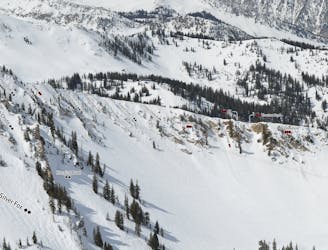
Steep chute under the tram
Freeride Skiing Severe

This is a popular freeride skiing route which is generally considered to be severe. It's not remote, it features high exposure (e3) and is typically done between January and March. From a low point of 3.1 km to the maximum altitude of 3.2 km, the route covers 152 m, 0 vertical metres of ascent and 111 vertical metres of descent. It's graded 4.3 and Labande grade 4.
Steep chute under the tram
Severe
Steep skiing at 38-45 degrees. This requires very good technique and the risk of falling has serious consequences.

In case of a fall, death is highly likely.

Close to help in case of emergency.
80 m away
A very steep and rocky way into Great Scott
Severe Freeride Skiing
106 m away

A popular double cliff air
Extreme Freeride Skiing
121 m away

A short but fun Macaroni shaped chute
Difficult Freeride Skiing
212 m away
A steep and tight chute with rocks
Extreme Freeride Skiing
408 m away
A cliff drop to straight line
Extreme Freeride Skiing
435 m away

A short, tight straight line
Extreme Freeride Skiing
480 m away

Steep technical skiing in the Forbidden Zone.
Extreme Freeride Skiing
564 m away

Steep chutes that are rarely open
Severe Freeride Skiing
565 m away

Secret gate that takes you just other side of rope line
Difficult Freeride Skiing
834 m away

Some V shaped airs
Extreme Freeride Skiing