4 m away
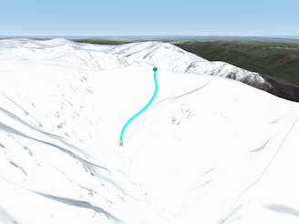
North Sentinel Chutes

Seriously steep, rugged terrain out here with changeable conditions
Severe Freeride Skiing
- Distance
- 512 m
- Ascent
- 57 m
- Descent
- 220 m
Amazing views with a consistent steep fall line from the peak of The Sentinel down to James Macarthur Creek
Freeride Skiing Severe

The south east chute of the Sentinel provides some of the steeper and more consistent lines on the south side of The Sentinel Ridge. After hiking up to the peak of The Sentinel you can choose whether to head down one of two fairly obvious chutes. A ridge heading to the south east separates the two lines, with the left line shorter and steeper and more obvious, whilst the other can only really be undertaken in a good season as it is rockier and narrower. Both of these lines feature a very steep gradient with rocks present either side, as the lines plummet towards James Macarthur Creek, so it is often best to scope the area from Carruther's Peak, or from another local vantage point. This area can be fairly icy in winter, and is definitely one which is better left for later in the day to soften up, that being said be aware of the avalanche risk as debris has been spotted in this area in the past. Other than that, these lines dish up some sensational skiing, and the views are just the icing on the cake. The best return from the base of this run is to follow the creek up, then boot pack up to the saddle on Sentinel Ridge.
Severe
Steep skiing at 38-45 degrees. This requires very good technique and the risk of falling has serious consequences.

As well as the slope itself, there are some obstacles (such as rock outcrops) which could aggravate injury.

Little chance of being seen or helped in case of an accident.
4 m away
Seriously steep, rugged terrain out here with changeable conditions
Severe Freeride Skiing
184 m away

Both a hike and a run and nothing beats the view.
Difficult Freeride Skiing
184 m away

Often loaded with snow, consistent fall lines and about 400 metres of vertical down into James Macarthur Creek
Difficult Freeride Skiing
669 m away

Some of the most unforgiving lines on the continent.
Extreme Freeride Skiing
1.2 km away
Dropping down into Watsons Creek, keeping skiers left of the creek
Difficult Freeride Skiing
1.3 km away

Falling away to the west of Tenison Woods Knoll, it acts as the western boundary of The Avalanche Face, heading steeply down to Strzelecki Creek
Severe Freeride Skiing
1.3 km away

Dropping South West of Tenison Woods Knoll, this provides a fairly open face with a variety of lines on offer leading down to Strzelecki Creek
Difficult Freeride Skiing
1.4 km away

Providing over 400 meters of vertical in a good snow year, these often overlooked runs, can offer some fantastic skiing.
Difficult Freeride Skiing
1.4 km away

Strzelecki Creek drops sharply granting an absolutely breathtaking view of the Sentinel before plunging westwards into some of the best terrain in Australia.
Difficult Freeride Skiing
1.4 km away

One of the most picturesque lines you will ever do.
Moderate Freeride Skiing
16 routes · Freeride Skiing · Ski Touring