0 m away
Black Pan 1

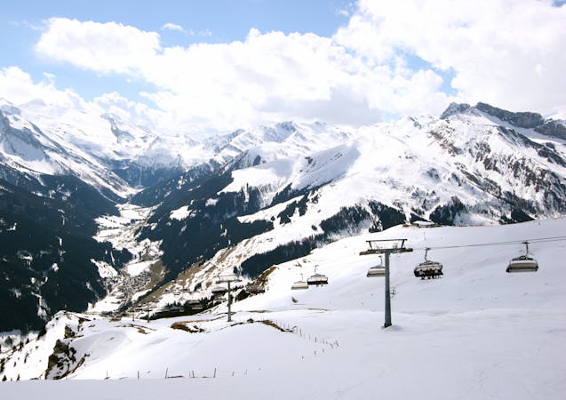
This route is a classic line here in Hintertux. Easy accessible, there is only a short hike needed.
Difficult Freeride Skiing
- Distance
- 2.1 km
- Ascent
- 42 m
- Descent
- 575 m
A short hike for long and joyful descent
Freeride Skiing Difficult

You reach the line using the four man chairlift up to Tuxerjoch and then follow the flat blue slope Tuxerjoch until it turns to the right at the Tuxerjoch Haus. You need to pass the restaurant on the left side and follow the road leading into the wide valley in front of you. Follow the road for 300 metres, it’s pretty flat here and you may need to shift all over the track on deep days. Turn to the right after 300 metres and hike up the 100 metres to the ridge. On the ridge you have a beautiful view out of the Tuxer valley. This is the perfect spot to take a deep breath, a picture and get ready for the freeride. You see the big cirque in front of you; the first 250 metres are quite steep, so think of leaving a safety gap between each other and be aware of avalanches. Look for the best entry at the top, looking for one without rocks and cliffs. After the first part it gets flat again and you have a nice spot on a ridge to wait. From here you see the crossing of the piste leading from right to left, when you look down. Go to the piste and cross it, following the flat part for 250 metres until it gets steeper. Now you have 2 options; going on the left side gives you a wide hill with some steep steps in it, going on the right provides you a nice tree run. The hill is about 500 metres long and ends at a small river, try to get past the river and follow it until a road appears, which leads you back up for 50 metres until you reach to the Schwarze Pfanne piste. At the end you will stop on the piste and follow it to the bottom station of Gletscherbus 1. This route is a good idea when there is fog on the top of the glacier, because it’s often sunny down here. That said, it is better to stay only in the tree run when the weather isn't that good.
Difficult
Serious gradient of 30-38 degrees where a real risk of slipping exists.

As well as the slope itself, there are some obstacles (such as rock outcrops) which could aggravate injury.
Away from help but easily accessed.
0 m away
This route is a classic line here in Hintertux. Easy accessible, there is only a short hike needed.
Difficult Freeride Skiing
516 m away

An easy route with a short hike which is nice on busy days
Difficult Freeride Skiing
4 km away

A short but impressive route on a wide glacier hill.
Difficult Freeride Skiing
4 km away

A breathtaking route here in Hintertux, the biggest and longest adventure in these parts.
Severe Freeride Skiing
4.1 km away

A short but intense line
Difficult Freeride Skiing
4.6 km away

A short route which is easily accessible.
Difficult Freeride Skiing
4.7 km away

A sunny, nice ride with a small channel at the end.
Difficult Freeride Skiing
4.7 km away

An easily accessible route down to the Schlegeis chairlift
Difficult Freeride Skiing
4.8 km away

A sunny line, recommended in Spring
Difficult Freeride Skiing
8.3 km away

Hike and Ride Route in the area of Eggalm. Bus ride back required
Difficult Freeride Skiing

7 routes · Freeride Skiing
6 routes · Freeride Skiing
7 routes · Freeride Skiing

10 routes · Freeride Skiing

10 routes · Freeride Skiing