490 m away
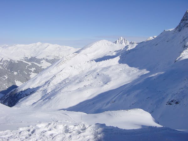
Olperer 2

A sunny line, recommended in Spring
Difficult Freeride Skiing
- Distance
- 1.2 km
- Ascent
- 0 m
- Descent
- 331 m
A sunny, nice ride with a small channel at the end.
Freeride Skiing Difficult

This route is only possible with an huge amount of snow over the winter, because at the beginning you need to go over the glacier and the risk of falling into a crevasse exists. The route is on a south facing slope an can also be done as a firm ride in Spring. You need to take the Olperer T-Bar to the top. You stop directly under the northeast wall of the Olperer. Stay next to the wall until you leave the slope. Then follow the wall to the east and cross the big hill beneath it for 750 metres. At the end the wall makes a steep step, until it gets flatter. You need to get to this point, that you can enter the hill on the south, be aware of rocks in the first few meters of the entry. Follow now the hill for 300 meters until you reach a wide hill, the perfect spot to watch your friends and wait for each other. Afterwards you need to go to the left in a channel throughout the cliffs. At the end it gets flat, so gain some speed to get back to the Schlegeis chairlift. As mentioned in the beginning, be aware of the crevasses at the beginning of the route, the safest time to go there is from March to May. In this time, you can either have powder or firn runs. The nearer you are to summer, the stronger the sun is up here at 3000m, so ski early on powder days or do the last runs before lunch here on firn days. Only do this route if you are confident with the situation on the glacier and when there is good weather forecasted, otherwise you will end up in a whiteout.
You are on a glacier so make sure you are equipped, prepared and have practised crevasse rescue, however unlikely you think falling in a crevasse is- it is possible! A minimum would be axe, crampons, an ice screw, a 30m rope, prussiks, several screwgates, a pulley and a couple of slings. A more modern simple solution might be a Petzl RAD system. If you have any doubts about this ski with an IFMGA Mountain Guide.
Difficult
Serious gradient of 30-38 degrees where a real risk of slipping exists.

As well as the slope itself, there are some obstacles (such as rock outcrops) which could aggravate injury.
Away from help but easily accessed.
490 m away
A sunny line, recommended in Spring
Difficult Freeride Skiing
617 m away

A short but intense line
Difficult Freeride Skiing
1.6 km away

An easily accessible route down to the Schlegeis chairlift
Difficult Freeride Skiing
1.6 km away

A breathtaking route here in Hintertux, the biggest and longest adventure in these parts.
Severe Freeride Skiing
1.6 km away

A short but impressive route on a wide glacier hill.
Difficult Freeride Skiing
1.8 km away

A short route which is easily accessible.
Difficult Freeride Skiing
4.2 km away

An easy route with a short hike which is nice on busy days
Difficult Freeride Skiing
4.7 km away

A short hike for long and joyful descent
Difficult Freeride Skiing
4.7 km away

This route is a classic line here in Hintertux. Easy accessible, there is only a short hike needed.
Difficult Freeride Skiing

7 routes · Freeride Skiing
7 routes · Freeride Skiing

10 routes · Freeride Skiing

10 routes · Freeride Skiing