516 m away
Black Pan 2

A short hike for long and joyful descent
Difficult Freeride Skiing
- Distance
- 1.8 km
- Ascent
- 9 m
- Descent
- 476 m
An easy route with a short hike which is nice on busy days
Freeride Skiing Difficult

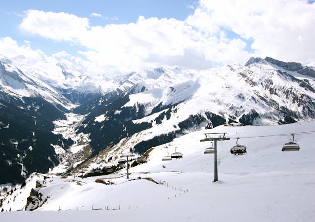
Take the four man chairlift at Sommerberg up to the Tuxerjoch. While riding the lift you can already see your face and check it - you'll see it in the left side above the button lift. Exit the lift to the right on top and get off your skis onto your backpack. Hike along the ridge on the left side for 250 metres and 50 meters to the top. On top of this small hill you have a wide view over the whole glacier and the whole valley. Here you can choose two different lines. Either you go directly straight down in the wide channel , where it is steeper on the beginning or you go a few meters more along the ridge and ski down the hill exposed to the north section. Here you can cross to the right after 150 meters after you've passed the cliffs beside. After 300 meters the hill is turning more to the east and you can look down to the button lift. Just follow this wide ridge in this direction. This is a short and easy route on busy days, especially it is not that crowded, because of the short hike. You need some weather conditions with a normal sight and without fog. At the beginning of the winter there is a few snow required to not get in touch with the small stones on the ground.
Difficult
Serious gradient of 30-38 degrees where a real risk of slipping exists.

As well as the slope itself, there are some obstacles (such as rock outcrops) which could aggravate injury.

Close to help in case of emergency.
516 m away
A short hike for long and joyful descent
Difficult Freeride Skiing
516 m away

This route is a classic line here in Hintertux. Easy accessible, there is only a short hike needed.
Difficult Freeride Skiing
3.6 km away

A short but intense line
Difficult Freeride Skiing
3.6 km away

A short but impressive route on a wide glacier hill.
Difficult Freeride Skiing
3.6 km away

A breathtaking route here in Hintertux, the biggest and longest adventure in these parts.
Severe Freeride Skiing
4.2 km away

A sunny, nice ride with a small channel at the end.
Difficult Freeride Skiing
4.2 km away

A short route which is easily accessible.
Difficult Freeride Skiing
4.3 km away

An easily accessible route down to the Schlegeis chairlift
Difficult Freeride Skiing
4.4 km away

A sunny line, recommended in Spring
Difficult Freeride Skiing
8.8 km away

Hike and Ride Route in the area of Eggalm. Bus ride back required
Difficult Freeride Skiing

7 routes · Freeride Skiing
6 routes · Freeride Skiing
7 routes · Freeride Skiing

10 routes · Freeride Skiing

10 routes · Freeride Skiing