84 m away
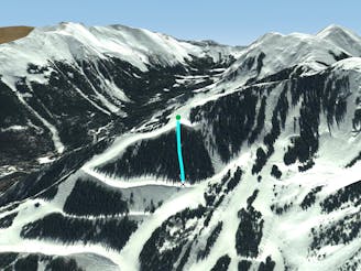
The Bambi Chutes.

A steep chute with trees.
Difficult Freeride Skiing
- Distance
- 365 m
- Ascent
- 0 m
- Descent
- 195 m
Steep and technical chutes needing a lot of snow.
Freeride Skiing Severe

The What Chutes? are a cluster of numbered, narrow, super-steep, technical lines right at the top of Lift 7A. Near the bottom, they open up and then enter the trees above Walkyries. They’re marked and the numbers count up the further down you go along Chair 7A. Go here when there’s a lot of snow, otherwise, you’ll spend a lot of your time picking your way down rather than skiing.
Severe
Steep skiing at 38-45 degrees. This requires very good technique and the risk of falling has serious consequences.

Away from help but easily accessed.
84 m away
A steep chute with trees.
Difficult Freeride Skiing
350 m away
Steep trees with a fun drop at the exit.
Difficult Freeride Skiing
380 m away

A chute with a rocky nose and narrow choke.
Severe Freeride Skiing
551 m away

A steep chute with trees and an open section.
Difficult Freeride Skiing
607 m away

A narrow, rocky spine.
Severe Freeride Skiing
614 m away

A line that splits the skier's left of T-Bird Trees and High Somewhere.
Difficult Freeride Skiing
624 m away

A short and fun shot through the trees.
Moderate Freeride Skiing
630 m away

A steep line through trees and big rocks.
Severe Freeride Skiing
637 m away

A hidden powder pocket in the trees.
Moderate Freeride Skiing
667 m away

Tight and steep trees.
Severe Freeride Skiing