74 m away
T-Bird Trees

Tight and steep trees.
Severe Freeride Skiing
- Distance
- 276 m
- Ascent
- 0 m
- Descent
- 171 m
A line that splits the skier's left of T-Bird Trees and High Somewhere.
Freeride Skiing Difficult

This is a popular freeride skiing route which is generally considered to be difficult. It's remote, it features unknown exposure and is typically done between December and April. From a low point of 3.4 km to the maximum altitude of 3.5 km, the route covers 115 m, 0 vertical metres of ascent and 83 vertical metres of descent.
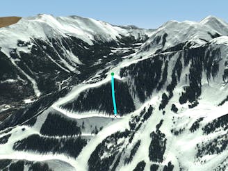
Black Dog is a tree-d line that angles right to left and connects T-Bird Trees with High Somewhere. Not too many people take the line, so if the new snow is getting tracked out elsewhere, Black Dog is worth a look.
Difficult
Serious gradient of 30-38 degrees where a real risk of slipping exists.

Away from help but easily accessed.
74 m away
Tight and steep trees.
Severe Freeride Skiing
94 m away

Runs along a technical spine then spills into open skiing.
Severe Freeride Skiing
123 m away

A narrow, rocky spine.
Severe Freeride Skiing
472 m away

A chute with a rocky nose and narrow choke.
Severe Freeride Skiing
585 m away

A steep chute with trees.
Difficult Freeride Skiing
590 m away
Steep trees with a fun drop at the exit.
Difficult Freeride Skiing
614 m away

Steep and technical chutes needing a lot of snow.
Severe Freeride Skiing
702 m away

A steep chute with trees and an open section.
Difficult Freeride Skiing
709 m away

A more difficult version of Whitefeather.
Easy Freeride Skiing
851 m away

A steep line through trees and big rocks.
Severe Freeride Skiing