84 m away
The What Chutes?

Steep and technical chutes needing a lot of snow.
Severe Freeride Skiing
- Distance
- 2 km
- Ascent
- 517 m
- Descent
- 693 m
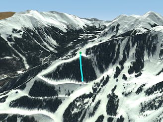
A steep chute with trees.
Freeride Skiing Difficult

This is a popular freeride skiing route which is generally considered to be difficult. It's very remote, it features unknown exposure and is typically done in an unknown time of year. From a low point of 3.4 km to the maximum altitude of 3.6 km, the route covers 365 m, 0 vertical metres of ascent and 195 vertical metres of descent.
The Bambi Chutes are lines off of Bambi that lead into the space between Sir Arnold Lunn and Walkyries Chute. The line is steep and has plenty of trees. There's a lot more skiing if you head left into Sir Arnold Lunn when you get to the bottom of the chutes.
Difficult
Serious gradient of 30-38 degrees where a real risk of slipping exists.

Little chance of being seen or helped in case of an accident.
84 m away
Steep and technical chutes needing a lot of snow.
Severe Freeride Skiing
266 m away
Steep trees with a fun drop at the exit.
Difficult Freeride Skiing
424 m away

A chute with a rocky nose and narrow choke.
Severe Freeride Skiing
468 m away

A steep chute with trees and an open section.
Difficult Freeride Skiing
552 m away

A steep line through trees and big rocks.
Severe Freeride Skiing
585 m away

A line that splits the skier's left of T-Bird Trees and High Somewhere.
Difficult Freeride Skiing
594 m away

A narrow, rocky spine.
Severe Freeride Skiing
643 m away

Tight and steep trees.
Severe Freeride Skiing
678 m away

Runs along a technical spine then spills into open skiing.
Severe Freeride Skiing
702 m away

A hidden powder pocket in the trees.
Moderate Freeride Skiing