54 m away
T-Bird Trees

Tight and steep trees.
Severe Freeride Skiing
- Distance
- 276 m
- Ascent
- 0 m
- Descent
- 171 m
Runs along a technical spine then spills into open skiing.
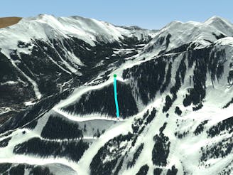
Freeride Skiing Severe

This is a popular freeride skiing route which is generally considered to be severe. It's remote, it features unknown exposure and is typically done between December and April. From a low point of 3.4 km to the maximum altitude of 3.6 km, the route covers 184 m, 0 vertical metres of ascent and 148 vertical metres of descent.
Despite its name, Hidden Chute is fairly well known. It starts with a long section down the spine between High Somewhere and Meatball then drops down a steep wall into the wide section of Meatball. It's fun!
Severe
Steep skiing at 38-45 degrees. This requires very good technique and the risk of falling has serious consequences.

Away from help but easily accessed.
54 m away
Tight and steep trees.
Severe Freeride Skiing
94 m away

A line that splits the skier's left of T-Bird Trees and High Somewhere.
Difficult Freeride Skiing
151 m away

A narrow, rocky spine.
Severe Freeride Skiing
537 m away

A chute with a rocky nose and narrow choke.
Severe Freeride Skiing
678 m away

A steep chute with trees.
Difficult Freeride Skiing
678 m away
Steep trees with a fun drop at the exit.
Difficult Freeride Skiing
701 m away

A more difficult version of Whitefeather.
Easy Freeride Skiing
706 m away

Steep and technical chutes needing a lot of snow.
Severe Freeride Skiing
779 m away

A steep chute with trees and an open section.
Difficult Freeride Skiing
929 m away

A steep line through trees and big rocks.
Severe Freeride Skiing