97 m away
T-Bird Trees

Tight and steep trees.
Severe Freeride Skiing
- Distance
- 276 m
- Ascent
- 0 m
- Descent
- 171 m
A narrow, rocky spine.
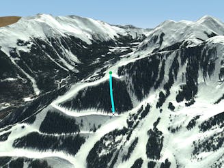
Freeride Skiing Severe

This is a popular freeride skiing route which is generally considered to be severe. It's remote, it features unknown exposure and is typically done between December and March. From a low point of 3.4 km to the maximum altitude of 3.6 km, the route covers 155 m, 0 vertical metres of ascent and 117 vertical metres of descent.
Bamboo Nose runs along the spine to skier's left from Bamboo Chute. This line is only possible with deep snow. When it is deep enough, you will still have to pick your way down until it begins to open up.
Severe
Steep skiing at 38-45 degrees. This requires very good technique and the risk of falling has serious consequences.

Away from help but easily accessed.
97 m away
Tight and steep trees.
Severe Freeride Skiing
123 m away

A line that splits the skier's left of T-Bird Trees and High Somewhere.
Difficult Freeride Skiing
151 m away

Runs along a technical spine then spills into open skiing.
Severe Freeride Skiing
390 m away

A chute with a rocky nose and narrow choke.
Severe Freeride Skiing
594 m away

A steep chute with trees.
Difficult Freeride Skiing
607 m away

Steep and technical chutes needing a lot of snow.
Severe Freeride Skiing
651 m away
Steep trees with a fun drop at the exit.
Difficult Freeride Skiing
786 m away

A steep chute with trees and an open section.
Difficult Freeride Skiing
830 m away

A more difficult version of Whitefeather.
Easy Freeride Skiing
932 m away

A steep line through trees and big rocks.
Severe Freeride Skiing