54 m away
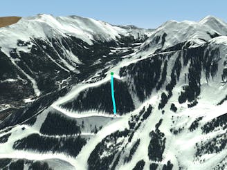
Hidden Chute

Runs along a technical spine then spills into open skiing.
Severe Freeride Skiing
- Distance
- 184 m
- Ascent
- 0 m
- Descent
- 148 m
Tight and steep trees.
Freeride Skiing Severe

Look for T-Bird Trees near the top of the small rise on the hike past Thunderbird. It now has a sign post on a tree. There are two options here; to the left is trees all the way to the skirt at the bottom. When this line is good, it's one of the best on the mountain. The right side starts with a narrow, critical column which feeds into the trees halfway down. This is classic Taos Ski Valley.
Severe
Steep skiing at 38-45 degrees. This requires very good technique and the risk of falling has serious consequences.

Away from help but easily accessed.
54 m away
Runs along a technical spine then spills into open skiing.
Severe Freeride Skiing
74 m away

A line that splits the skier's left of T-Bird Trees and High Somewhere.
Difficult Freeride Skiing
97 m away

A narrow, rocky spine.
Severe Freeride Skiing
484 m away

A chute with a rocky nose and narrow choke.
Severe Freeride Skiing
643 m away

A steep chute with trees.
Difficult Freeride Skiing
662 m away
Steep trees with a fun drop at the exit.
Difficult Freeride Skiing
667 m away

Steep and technical chutes needing a lot of snow.
Severe Freeride Skiing
745 m away

A more difficult version of Whitefeather.
Easy Freeride Skiing
776 m away

A steep chute with trees and an open section.
Difficult Freeride Skiing
925 m away

A steep line through trees and big rocks.
Severe Freeride Skiing