405 m away
Hannes Schneider

A short glade.
Difficult Freeride Skiing
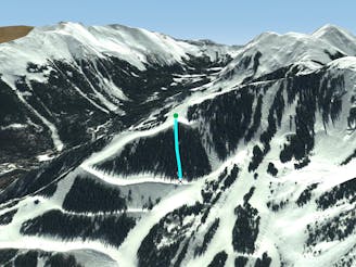
- Distance
- 291 m
- Ascent
- 0 m
- Descent
- 118 m
A more difficult version of Whitefeather.
Freeride Skiing Easy

This is a popular freeride skiing route which is generally considered to be easy. It's not remote, it features unknown exposure and is typically done in an unknown time of year. From a low point of 3.2 km to the maximum altitude of 3.2 km, the route covers 137 m, 0 vertical metres of ascent and 47 vertical metres of descent.
Whitefeather Bowl descends from one of the switchback sections of Whitefeather. It’s short, but more challenging than Whitefeather. At times all of Whitefeather Bowl may not be groomed, but once the bumps start to form, they get mowed down.
Easy
Wide gentle slopes at around 20 degrees or less.

Close to help in case of emergency.
405 m away
A short glade.
Difficult Freeride Skiing
517 m away

A mixed bag in the trees.
Moderate Freeride Skiing
701 m away

Runs along a technical spine then spills into open skiing.
Severe Freeride Skiing
709 m away

A line that splits the skier's left of T-Bird Trees and High Somewhere.
Difficult Freeride Skiing
730 m away

A steep chute with trees and an open section.
Difficult Freeride Skiing
730 m away

A short shot through the trees.
Moderate Freeride Skiing
745 m away

Tight and steep trees.
Severe Freeride Skiing
819 m away
Steep trees with a fun drop at the exit.
Difficult Freeride Skiing
830 m away

A steep line through trees and big rocks.
Severe Freeride Skiing
830 m away

A narrow, rocky spine.
Severe Freeride Skiing