150 m away
R and R

A steep line through trees and big rocks.
Severe Freeride Skiing
- Distance
- 235 m
- Ascent
- 0 m
- Descent
- 139 m
A steep chute with trees and an open section.
Freeride Skiing Difficult

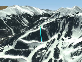
Werner Trib is the first line after passing through the Werner gate. It’s more open than Werner proper, particularly at the bottom. The top part has some trees then in the middle it gets a little cliffy sometimes. Werner Trib spills into Longhorn, so there's still quite a ways to go before you're back on the flats. Ski this line with a partner.
Difficult
Serious gradient of 30-38 degrees where a real risk of slipping exists.

Away from help but easily accessed.
150 m away
A steep line through trees and big rocks.
Severe Freeride Skiing
204 m away
Steep trees with a fun drop at the exit.
Difficult Freeride Skiing
468 m away

A steep chute with trees.
Difficult Freeride Skiing
551 m away

Steep and technical chutes needing a lot of snow.
Severe Freeride Skiing
702 m away

A line that splits the skier's left of T-Bird Trees and High Somewhere.
Difficult Freeride Skiing
710 m away

A short glade.
Difficult Freeride Skiing
730 m away

A more difficult version of Whitefeather.
Easy Freeride Skiing
776 m away

Tight and steep trees.
Severe Freeride Skiing
779 m away

Runs along a technical spine then spills into open skiing.
Severe Freeride Skiing
786 m away

A narrow, rocky spine.
Severe Freeride Skiing