57 m away
Devil's Castle Couloir

A steep technical line that is very rarely skied
Extreme Freeride Skiing
- Distance
- 299 m
- Ascent
- 9 m
- Descent
- 163 m
A long steep powder run
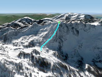
Freeride Skiing Difficult

This is a popular freeride skiing route which is generally considered to be difficult. It's remote, it features medium exposure (e2) and is typically done in an unknown time of year. From a low point of 3.1 km to the maximum altitude of 3.3 km, the route covers 481 m, 0 vertical metres of ascent and 246 vertical metres of descent.
If you get the chance to ski the middle line down East Castle then you are very lucky; it's one of the best runs at Alta and rarely open. Get playful with jumps and cliffs or rip high speed turns down the open face. If it's open, it is well worth the hike.
Difficult
Serious gradient of 30-38 degrees where a real risk of slipping exists.

As well as the slope itself, there are some obstacles (such as rock outcrops) which could aggravate injury.
Away from help but easily accessed.
57 m away
A steep technical line that is very rarely skied
Extreme Freeride Skiing
57 m away
Long steep powder skiing
Difficult Freeride Skiing
1.2 km away

Skinny chute skiing
Difficult Freeride Skiing
1.2 km away

A short and steep chute
Severe Freeride Skiing
2.2 km away

The steep headwall looker's left of Main Chute and Little Chute on Mount Baldy
Severe Freeride Skiing
2.4 km away

A variation of Little Chute
Severe Freeride Skiing
2.4 km away

Little Chute is the skinnier and more technical couloir to skiers right of the popular Main Chute on Mount Baldy
Severe Freeride Skiing
2.5 km away

Steep chutes that are rarely open
Severe Freeride Skiing
2.6 km away

A hidden powder stash in the chute above High Nowhere
Difficult Freeride Skiing
2.7 km away

Cliff drops and technical lines of all shapes and sizes
Severe Freeride Skiing