0 m away
1st Chute
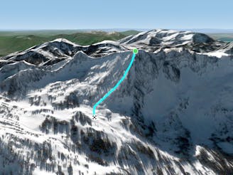
Long steep powder skiing
Difficult Freeride Skiing
- Distance
- 534 m
- Ascent
- 0 m
- Descent
- 260 m
A steep technical line that is very rarely skied
Freeride Skiing Extreme

This line is almost better to look at than to actually ski. It is rarely open and rarely has enough snow to make it worth your while. It is the obvious couloir that extends above the Castle Apron starting from the top saddle of the Devil's Castle. The line is very steep, technical and usually quite complex - look to this line for an incredible challenge and likely suffer fest. This line only fills in during big snow years and usually has a cornice on top. It is for experts only - it is obvious why when you see it.
Extreme
Extreme skiing terrain above 45 degrees. These routes are reserved for experienced experts.

In case of a fall, death is highly likely.

Away from help but easily accessed.
0 m away
Long steep powder skiing
Difficult Freeride Skiing
57 m away

A long steep powder run
Difficult Freeride Skiing
1.2 km away

Skinny chute skiing
Difficult Freeride Skiing
1.3 km away

A short and steep chute
Severe Freeride Skiing
2.2 km away

The steep headwall looker's left of Main Chute and Little Chute on Mount Baldy
Severe Freeride Skiing
2.4 km away

A variation of Little Chute
Severe Freeride Skiing
2.4 km away

Little Chute is the skinnier and more technical couloir to skiers right of the popular Main Chute on Mount Baldy
Severe Freeride Skiing
2.5 km away

Steep chutes that are rarely open
Severe Freeride Skiing
2.5 km away

A hidden powder stash in the chute above High Nowhere
Difficult Freeride Skiing
2.6 km away

Cliff drops and technical lines of all shapes and sizes
Severe Freeride Skiing