Red Rocks -> Morrison Slide North Lollipop

Enjoy scenic views from the upper reaches of Matthews Winters Open Space.
Moderate Trail Running
- Distance
- 7.9 km
- Ascent
- 248 m
- Descent
- 248 m
Explore Colorado with curated guides of the best hiking trails, mountain bike trails, trail running routes, ski routes, and more. With over 1641 3D trail maps in FATMAP, you can easily discover and navigate the best trails in Colorado.
No matter what your next adventure has in store, you can find a guide on FATMAP to help you plan your next epic trip.
Get a top trail recommendation in Colorado from one of our 149 guidebooks, or get inspired by the 1641 local adventures uploaded by the FATMAP community. Start exploring now!
Enjoy scenic views from the upper reaches of Matthews Winters Open Space.
Moderate Trail Running

A gorgeous loop circumnavigating Centennial Cone.
Difficult Hiking
A gorgeous loop circumnavigating Centennial Cone.
Moderate Trail Running

A gorgeous loop circumnavigating Centennial Cone.
Difficult Mountain Biking

Extremely steep gladed zone at Aspen Highlands
Extreme Freeride Skiing

tree run at winter park
Extreme Freeride Skiing

assess to the terrain past G chute
Extreme Freeride Skiing

A long-distance recreational path following an irrigation canal.
Easy Gravel Biking

A long-distance recreational path following an irrigation canal.
Easy Road Biking

A long-distance recreational path following an irrigation canal.
Easy Trail Running
A long-distance recreational path following an irrigation canal.
Easy Hiking
A beautiful. nature walk in the heart of Denver.
Easy Hiking

A short, easy loop walk around a small lake.
Easy Hiking

A short, easy loop walk around a small lake.
Easy Hiking

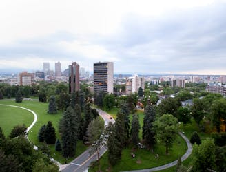
An easy walk with an iconic view of the Denver skyline.
Easy Hiking

An easy but scenic loop along both banks of Bear Creek.
Easy Hiking