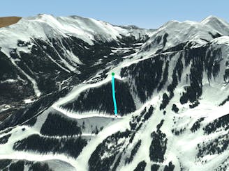
Paws
An extreme couloir with cliff and rocks.
Extreme Freeride Skiing
- Distance
- 191 m
- Ascent
- 0 m
- Descent
- 128 m
Explore New Mexico with curated guides of the best hiking trails, mountain bike trails, trail running routes, ski routes, and more. With over 207 3D trail maps in FATMAP, you can easily discover and navigate the best trails in New Mexico.
No matter what your next adventure has in store, you can find a guide on FATMAP to help you plan your next epic trip.
Get a top trail recommendation in New Mexico from one of our 28 guidebooks, or get inspired by the 207 local adventures uploaded by the FATMAP community. Start exploring now!
An extreme couloir with cliff and rocks.
Extreme Freeride Skiing

Steep and technical chutes needing a lot of snow.
Severe Freeride Skiing
Steep trees with a fun drop at the exit.
Difficult Freeride Skiing

Runs along a technical spine then spills into open skiing.
Severe Freeride Skiing

A fun ramble through the trees.
Moderate Freeride Skiing

A line that splits the skier's left of T-Bird Trees and High Somewhere.
Difficult Freeride Skiing

A wide blue, with some moguls on the far side.
Easy Freeride Skiing

A steep, extreme line into Hunziker Main
Extreme Freeride Skiing

A ramp-like wall dumping into Hunziker.
Severe Freeride Skiing

A fun slot through the rocks.
Moderate Freeride Skiing

Tree and open lines with full southern exposure.
Difficult Freeride Skiing

An interesting lines through moguls and big rocks.
Moderate Freeride Skiing

An extreme, technical line with cliffs and rocks.
Extreme Freeride Skiing

A steep chute with trees and an open section.
Difficult Freeride Skiing

A steep line through trees and big rocks.
Severe Freeride Skiing

A short shot through the trees.
Moderate Freeride Skiing